Wednesday, 31 August 2011

Mud Springs (William Henry Jackson, Yellowstone, 1871)


.

Yellowstone National Park, Wyoming. Mud Springs at Crater Hills near Sulphur Spring. The contents of this spring are a fine, siliceous, pearl-colored mud, the consistency of thick, hasty pudding. The surface is covered with puffs of mud, which, as they burst, give off a thud-like noise, and then the paint-like liquid recedes from the center of the puffs in a perfect series of rings to the side. The explosion is produced by the escape of sulfurated hydrogen gas through the mud. 1871.U.S. Geological and Geographical Survey of the Territories (Hayden Survey).

Yellowstone National Park, Wyoming. Mud Springs at Crater Hills near Sulphur Spring. The contents of this spring are a fine, siliceous, pearl-colored mud, the consistency of thick, hasty pudding. The surface is covered with puffs of mud, which, as they burst, give off a thud-like noise, and then the paint-like liquid recedes from the center of the puffs in a perfect series of rings to the side. The explosion is produced by the escape of sulfurated hydrogen gas through the mud: from U.S. Geological and Geographical Survey of the Territories, 1871 (Hayden Survey)


Puffs of

mud


produced

by the escape


of sulfurated

hydrogen gas


spring

like hope


eternal

and when burst


like hope

give off


a thud

like noise


as the paint

like liquid


secreted

by realism


recedes

in a perfect


series of

rings


to the side


Yellowstone National Park, Wyoming. Mud Geyser in action. The only true mud geyser discovered, 8 miles below Yellowstone Lake. It has a funnel-shaped orifice in the center of a basin 150 feet in diameter and in which there are two other hot mud springs. The flow of the geyser is regularly every six hours, the eruptions lasting about fifteen minutes. The thick, muddy water rises gradually in the crater, commencing to boil when about half-way to the surface, and occasionally breaking forth with great violence. When the crater is filled, it is expelled from it in a splashing, scattered mass, 10 feet in diameter, to 40 feet in height. The mud is a dark lead-color and deposits itself all about the rim of the crater. 1871.U.S. Geological and Geographical Survey of the Territories (Hayden Survey).

Yellowstone National Park, Wyoming. Mud Geyser in action. The only true mud geyser discovered, 8 miles below Yellowstone Lake. It has a funnel-shaped orifice in the center of a basin 150 feet in diameter and in which there are two other hot mud springs. The flow of the geyser is regularly every six hours, the eruptions lasting about fifteen minutes. The thick, muddy water rises gradually in the crater, commencing to boil when about half-way to the surface, and occasionally breaking forth with great violence. When the crater is filled, it is expelled from it in a splashing, scattered mass, 10 feet in diameter, to 40 feet in height. The mud is a dark lead-color and deposits itself all about the rim of the crater: from U.S. Geological and Geographical Survey of the Territories, 1871 (Hayden Survey)

Photos by William Henry Jackson from United States Geological Surveys (U. S. Geological Survey Photographic Library)

Tuesday, 30 August 2011

Over the Falls (William Henry Jackson: Mystic Lake, Montana, 1871)


.

Mystic Lake, distant view from the trail. The first glimpse as we approach it. Gallatin County, Montana. 1871.

Mystic Lake, distant view from the trail. The first glimpse as we approach it. Gallatin County, Montana, 1871


imagining

the morning's clarity


from the evening's

blurred impingement

from up the creek or down

not easy

over the falls

Mystic Lake

looked

so beautiful


from a distance

that first glimpse

shining

beyond the bright

meanders

beneath black

pine slopes

as we approached

it


but a dim memory

now


View down the creek a short distance below Mystic Lake. The creek falls very rapidly, some 500 feet in less than half a mile. Gallatin County, Montana. 1871.

View down the creek a short distance below Mystic Lake. The creek falls very rapidly, some 500 feet in less than half a mile. Gallatin County, Montana, 1871

View down the creek a short distance below Mystic Lake. The creek falls very rapidly, some 500 feet in less than half a mile. Gallatin County, Montana. 1871.

View down the creek a short distance below Mystic Lake. The creek falls very rapidly, some 500 feet in less than half a mile. [Falls of the creek seen at bottom of the photograph.] Gallatin County, Montana, 1871

Photos by William Henry Jackson from United States Geological Surveys (U. S. Geological Survey Photographic Library)

Monday, 29 August 2011

Escape from New York (Not)


.

New York skyline is enveloped in the dark clouds as Hurricane Irene approaches

The New York skyline, with the Statue of Liberty just visible on the left, is enveloped in dark clouds as Hurricane Irene advances, August 28 2011: photo by Keystone/Rex Features


An employee boards up the windows of a store in Amagansett, East Hampton, New York, 28 August 2011: photo by Lucas Jackson/Reuters


People sheltering at Penn Station in New York grab some shuteye, 28 August 2011: photo by Chelsea Matiash/AP


Workmen install plywood over the windows of Bloomingdale's department store in New York, 28 August 2011: photo by Karly Domb Sadof/AP


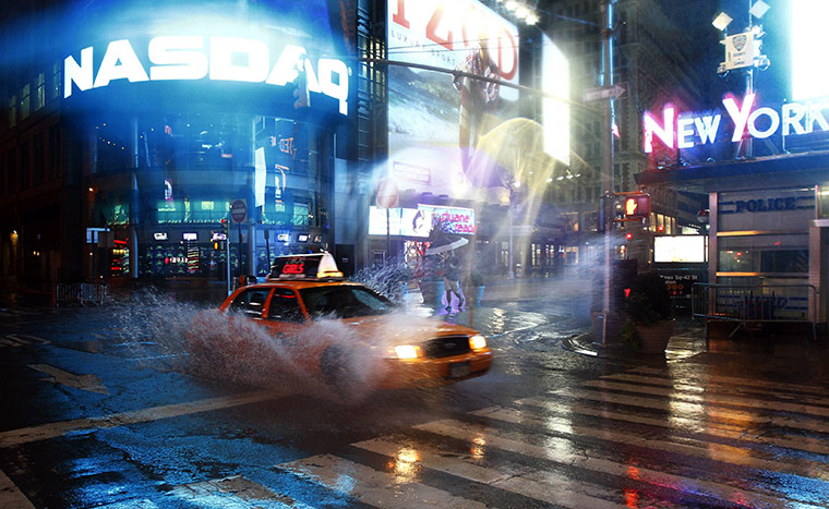
A taxi 42nd Street at Times Square in New York as rain falls before hurricane Irene hit, 28 August 2011. The city was shut down as millions of Americans sought shelter from a huge storm that closed transport systems: photo by Peter Jones/Reuters

Hurricane Irene leaves Manhattan almost unscathed

New York dodges meteorological bullet and life returns to normal

by Paul Harris, The Guardian, 28 August 2011

No sooner had the roaring winds and driving rains of Hurricane Irene passed overhead than the denizens of lower Manhattan emerged to celebrate the storm that wasn't.

The area of the city sandwiched between the Hudson and East rivers had been a main focus of concern as Irene bore down on the metropolis...

But as the waters rose along the East River Park and along the West Side highway, they quickly reached their peak and then receded. A few streets flooded, the odd car was stranded, but on the whole the feared "storm surge" that could have swamped the city failed to materialise. Lower Manhattan had dodged a meteorological bullet.

For ordinary citizens it was an immense relief, tempered with a typical New York attitude that dictates that one must shrug nonchalantly in the face of danger.

Melanie Marchenko, 48, had come in from New Jersey to spend the night with her elderly mother in lower Manhattan. She claimed to be unfazed by all the fuss. "It was nice. It was serene," she said of the 65mph winds that had howled through the night.

The most unusual thing was the way normally bustling New York had become deserted as public transport closed and forced everyone indoors. "It felt kind of like a ghost town," she said, clutching her morning copy of the Daily News, which she had bought at a corner store deli that had remained open.

Even as city officials urged people to remain indoors once the hurricane had passed, many in lower Manhattan ignored the advice. It is not every day that a hurricane visits the neighbourhood and the curious and the concerned wanted to grab a look first hand.

The scene that greeted them was one of autumn come early: leaves and branches littered New York's pavements and roads. Most stores and businesses remained closed, sometimes with tape criss-crossed across the windows –- a salient reminder of the fear that Irene had inspired.

But, on the whole, life began to return to normal amid a light drizzle on a comparatively windless late morning, as Irene whirled away northwards.

Joggers put on their earphones and headed down to the rivers for late morning runs; families with young children went for walks; and a few elderly people straggled into the old Polish church of St Stanislaus on East 7th Street which had opened its doors for a morning service. Store owners laid out boxes of fruit and vegetables.

Hair stylist Carlos Franqui, 32, was taking his two Shih Tzu dogs for a morning walk. Franqui said he had been first amazed at the idea of a hurricane hitting New York at all, and then surprised a second time when the promised disaster failed to happen.

Even his small, ornamental pets were not impressed by Irene. "It did not bother them at all. They slept through it," he said. "I got up this morning and was like: 'All right, nothing happened'."

Of course, Franqui's attitude might have been shaped by the fact that he is originally from Puerto Rico and as a boy survived the assault on the island of the category 5 monster Hurricane Hugo in 1989.

"This was not much like that. This was nothing, but I guess it is always good to be careful," he said.


Manhattan's Times Square

The threat of Hurricane Irene failed to stop tourists visiting Manhattan's Times Square, despite warnings from New York mayor Michael Bloomberg, 28 August 2011: photo by John Minchillo/AP

irenemap.jpg

"You know what time it is, America? Time to FREAK THE FUCK OUT!": graphic and caption via Village Voice, 28 August 2011

Sunday, 28 August 2011

Natural Reaction (William Henry Jackson, Bombay, 1895)


.

File:William Henry Jackson-Fleeing camera.jpg

Woman and children fleeing camera, Bombay, 1895


when the shooting began
ran
in panic
from the white man
with the magic box
beneath the black cloth


File:William Henry Jackson-People on sidewalk.jpg

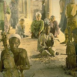
Street musicians playing stringed instruments and other people squatting on sidewalk, British India, 1895

Photos by William Henry Jackson (1843-1942)

Saturday, 27 August 2011

Cahokia


.

http://upload.wikimedia.org/wikipedia/commons/9/9c/Birger_figurine_%281%29.jpg

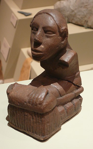
Pre-Columbian figurine from Cahokia Mounds, site of largest indigenous city north of the Mesoamerican urban centers of Mexico, near present-day Collinsville, Illinois: photo by Tim Vickers, 3 January 2009


The tented outdoor bar and tables, the sparkling glints of diamond light created by the reflections dancing off the tall thin-stemmed champagne glasses, the cool jazz drifting from within and the impressive row of black limousines lined up out front, the magnificent spectacle of liberal wealth displaying itself in the midst of the decline of empire, the heavy unsmiling bodyguards eyeing the proceedings from a discreet vantage, the quietly imposing entourages of Governor and Senator, the bustling of the young stylishly outfitted help, the air of celebrity and of fine stock profile and of the cultural satiation of the permanently indulged, the privileged yet never quite satisfied, lay thick upon the foggy pall of night air enveloping the Avenue of the Possessed and Dispossessed, street of extreme wealth and extreme poverty uncomfortably superimposed, the ambient pungent aroma of unimaginably savoury and expertly prepared delicacies immaculately and discreetly served, the poor kept well out of the way, loitering without intent or lying upon cardboard pallets in the doorways of closed shops, as my shadow passed in disconnected contemplation...

Thinking of the paranoia of Constantine, the intense authoritarian efforts of Domitian and Constantine to maintain cohesion, to retain power, all for naught in the end, the black tide could not be resisted, the collapse was compelled onward by its own momentum, the overlayering of social strata, the proliferation of specialized economic roles, the rise of the information producers and analysts, the decline of real production on the part of the accumulators of crucial resources, the fragmentation of what had once been a whole into multiple distinct and incompatible social units, the increasing strain on the population at large, the dismembered remains of the victims of ritual sacrifice stacked in the dreaming mounds left after the mysterious fall of the dominant city of the Mississippian culture, Cahokia, largest urban center north of the great Mesoamerican complexes of Mexico, a London or Paris of pre-Columbian times, with its cruel falcon gods, its fictive kinship rituals, its terminated bureaucracies and lost chiefdom lineages and intricate class structures buried under a millennial burden of dirt and forgetfulness, the digits of the inhabitants of the mass graves locked eternally in a clawing position as they struggle forever to climb upward through the impossible weight from above ...


File:Keller figurine.jpg
Pre-Columbian figurine from Cahokia Mounds site: photo by Tim Vickers, 3 January 2009

File:Cahokia monks mound HRoe 2008.jpg

Monk's Mound, largest earthen structure at the Cahokia site, near Collinsville, Illinois: photo by Herb Rowe, 19 September 2008 


File:Cahokia Mound 72.jpg

Mound 72 at Cahokia, a ridge-top burial mound south of Monk's Mound, where archaeologists found the remains of a man in his 40s who was probably an important Cahokian ruler. The man was buried on a bed of more than 20,000 marine-shell disc beads arranged in the shape of a falcon
, with the bird's head appearing beneath and beside the man's head, and its wings and tail beneath his arms and leg. Of the nearly three hundred skeletons discovered in Mound 7, the majority were determined to be sacrificial victims (including four young males missing hands and skulls, and more than fifty young women in a single mass grave, the remains segregated in two layers separated by matting): photo by Carptrash, September 2001
 
http://upload.wikimedia.org/wikipedia/commons/1/1d/Cahokia_2.jpg
St. Louis as seen from Monk's Mound, largest of the earthen structures at the Cahokia site: photo by Carptrash, September 2001

Edward Dorn: After Ore / William Henry Jackson: Hydraulic Mining, Madison County, Montana, 1871


.

Hydraulic mining in Alder Gulch, near Virginia City. Madison County, Montana. 1872.

Hydraulic mining in Alder Gulch, near Virginia City. Madison County, Montana, 1872


So he goes anywhere apparently

anywhere and space is muddied

with his tracks

for ore he is only after,

after ore.


Hydraulic mining near Virginia City. Alder Gulch is 16 miles in length, rising in the mountains near Madison river at an altitude of 7,500 feet. The view shows the manner of washing away the sides of the gulch into the sluice-boxes, where the gold is collected. Madison County, Montana. 1871.

Hydraulic mining near Virginia City. Alder Gulch is 16 miles in length, rising in the mountains near Madison river at an altitude of 7,500 feet. The view shows the manner of washing away the sides of the gulch into the sluice-boxes, where the gold is collected. Madison County, Montana, 1871

Hydraulic mining near Virginia City. Alder Gulch is 16 miles in length, rising in the mountains near Madison River at an altitude of 7,500 feet. A flume is laid upon the bedrock, in the bottom of the gulch, and the waters of the creek brought through it, carrying with its current the auriferous sands. Madison County, Montana. 1871.

Hydraulic mining near Virginia City. Alder Gulch is 16 miles in length, rising in the mountains near Madison River at an altitude of 7,500 feet. A flume is laid upon the bedrock, in the bottom of the gulch, and the waters of the creek brought through it, carrying with its current the auriferous sands. Madison County, Montana, 1871

"So he goes anywhere...": Edward Dorn: Idaho Out (excerpt), 1965

Photos by William Henry Jackson from United States Geological Surveys (U. S. Geological Survey Photographic Library)

Friday, 26 August 2011

Edward Dorn: The Sundering U.P. Tracks / William Henry Jackson: Rock Cuts along the Union Pacific, 1869


.

Burning Rock cut, near Green River Station. Sweetwater County, Wyoming. 1869.

Burning Rock cut, near Green River Station. Sweetwater County, Wyoming, 1869


Every little bogus town

on the Union Pacific bears the scar

of an expert linear division...


Each side of the shining double knife

from Chicago to Frisco

to Denver, the Cheyenne cutoff

the Right of Way they called it

and still it runs that way

right through the heart

the Union Pacific rails run also to Portland.

Even through the heart of the blue beech

hard as it is.


Glimpses along the west bank of Green River between Green River Station and Burning Rock cut, showing to good advantage the wall-like and castellated forms on the opposite side of the river. Sweetwater County, Wyoming. 1869.

Glimpse along the west bank of Green River between Green River Station and Burning Rock cut, showing to good advantage the wall-like and castellated forms on the opposite side of the river. Sweetwater County, Wyoming, 1869

Glimpses along the west bank of Green River between Green River Station and Burning Rock cut, showing to good advantage the wall-like and castellated forms on the opposite side of the river. Sweetwater County, Wyoming. 1869.

Along the west bank of Green River between Green River Station and Burning Rock cut. Sweetwater County, Wyoming, 1869

Glimpses along the west bank of Green River between Green River Station and Burning Rock cut, showing to good advantage the wall-like and castellated forms on the opposite side of the river. Sweetwater County, Wyoming. 1869.

Union Pacific line along the west bank of Green River between Green River Station and Burning Rock cut. Sweetwater County, Wyoming, 1869

Granite Cut, near Dale Creek Bridge, about 3 miles west of Sherman. The road has been drilled and blasted through a close, compact, and massive granite that is susceptible of a high polish, much like the Scottish syenite. Albany County, Wyoming. 1869.

Granite Cut, near Dale Creek Bridge, about 3 miles west of Sherman[, Wyoming]. The road has been drilled and blasted through a close, compact, and massive granite that is susceptible of a high polish, much like the Scottish syenite. Albany County, Wyoming, 1869

Tunnel No. 2, the longest on the road, 770 feet in length, cut through reddish and purplish indurated clays, of the Wasatch group of Miocene Tertiary. Summit County, Utah. 1869.

Tunnel No. 2, the longest on the road, 770 feet in length, cut through reddish and purplish indurated clays, of the Wasatch group of Miocene Tertiary. Summit County, Utah, 1869

Devils Gate Bridge. The most attractive feature of the canyon is the roar of the waters of the Weber as they roll over the immense masses of rock in its bed, with the rush and tumult of a mountain torrent. For 4 miles we are enclosed with nearly perpendicular walls of gneiss, 2,000 feet in height, forming the central portion of the Wasatch Mountains; the river rushing through it at right angles. The rocks are beautifully banded everywhere. There are also coarse aggregations of quartz and feldspar all along the sides of this channel; and high up on the steep mountain flanks are vast deposits of boulders and fine sand. Weber County, Utah. 1869.

Devils Gate Bridge. The most attractive feature of the canyon is the roar of the waters of the Weber as they roll over the immense masses of rock in its bed, with the rush and tumult of a mountain torrent. For 4 miles we are enclosed with nearly perpendicular walls of gneiss, 2,000 feet in height, forming the central portion of the Wasatch Mountains; the river rushing through it at right angles. The rocks are beautifully banded everywhere. There are also coarse aggregations of quartz and feldspar all along the sides of this channel; and high up on the steep mountain flanks are vast deposits of boulders and fine sand. Weber County, Utah, 1869

There would seem to loom only facts: that boulder, this mountain, these store fronts, his greed, her compassion, water, no water, prayer, arrogance, futility, loneliness, a swindle, an even break, the dandy charmer, the slothful soilbound fanatic, the dream and of course the inevitable dreamer. History has always seemed to me lying on the table, forgetful of age, or not present at all. And geography is not what's under your foot, that's simply the ground.

-- Edward Dorn: Idaho Out, 1965, Preface

The objects which exist together in the landscape exist in inter-relation. We assert that they constitute a reality as a whole that is not expressed by a consideration of the constituent parts separately, that area has form, structure and function, and hence position in a system, and that it is subject to development, change and completion. Without this view of areal reality and relation, there exist only special disciplines, not geography...

-- Carl O. Sauer, from The Morphology of Landscape, 1925

"Every little bogus town...": Edward Dorn: The Sundering U.P. Tracks (excerpt), from North Atlantic Turbine, 1967

Photos by William Henry Jackson from United States Geological Surveys (U. S. Geological Survey Photographic Library)

Thursday, 25 August 2011

Robert Creeley: Heroes / William Henry Jackson: The Mountains and the Desert


.

The Annie.

The Annie. "First Boat Ever Launched on Yellowstone Lake." Reported to first be used on June 29, 1871: U.S. Geological and Geographical Survey of the Territories, Yellowstone Series, 1871, Vol. III (Hayden Survey)


In those stories the hero
is beyond himself into the next
thing, be it those labors
of Hercules, or Aeneas going into death.

I thought the instant of the one humanness
in Virgil's plan of it

was that it was of course human enough to die,
yet to come back, as he said, hoc opus, hic labor est.

That was the Cumaean Sibyl speaking.
This is Robert Creeley, and Virgil
is dead now two thousand years, yet Hercules
and the Aeneid, yet all that industrious wis-

dom lives in the way the mountains
and the desert are waiting
for the heroes, and death also
can still propose the old labors.


Robert Creeley: Heroes, from For Love, 1960


Yellowstone Lake.

Yellowstone Lake. "Mary's Bay": U.S. Geological and Geographical Survey of the Territories, Yellowstone Series, 1871, Vol. III (Hayden Survey)

Reeds Rock, near Sherman, forms an excellent illustration of the style of weathering of the granites, characteristic of this region. These massive piles, like the ruins of old castles, are scattered all over the summits of the Black Hills, and the difference in the texture of the rock is such as to give a most pleasing variety of outline. They were once angular, cube-like masses, and have been worn to their present forms by the process of disintegration by exfoliation. Albany County, Wyoming. 1869.

Reeds Rock, near Sherman, [Wyoming,] forms an excellent illustration of the style of weathering of the granites, characteristic of this region. These massive piles, like the ruins of old castles, are scattered all over the summits of the Black Hills, and the difference in the texture of the rock is such as to give a most pleasing variety of outline. They were once angular, cube-like masses, and have been worn to their present forms by the process of disintegration by exfoliation. Albany County, Wyoming. 1869

Giants Club, a rock pinnacle near Green River Station. Sweetwater County, Wyoming. 1869.

Giants Club, a rock pinnacle near Green River Station. Sweetwater County, Wyoming, 1869

"Grand Canyon of the Colorado." [Possibly view in Lower Granite Gorge, Grand Canyon of the Colorado River.] Men in foreground. Mohave County, Arizona, c. 1883

Yellowstone National Park, Wyoming. Old Faithful in Upper Geyser Basin in eruption, probably viewed from the side nearest the Firehole River. Photo probably by W.H. Jackson, either 1878 (Hayden Survey), 1883, or 1885 (for W.H. Jackson & Co., Denver).

Yellowstone National Park, Wyoming. Old Faithful in Upper Geyser Basin in eruption [probably viewed from the side nearest the Firehole River]: U.S. Geological and Geographical Survey of the Territories, 1878 (Hayden Survey)

Pulpit Terraces. Mammoth Hot Springs. Yellowstone National Park, Wyoming. Ca. 1883. Published as figure 10 in New Mexico University Press. Second view Rephotographic Survey Project. Copyrighted 1984.

Pulpit Terraces. Mammoth Hot Springs. Yellowstone National Park, Wyoming, c. 1883

The Upper Twin Lake. Lake Couty, Colorado. 1875. Published as figure 52 in New Mexico University Press. Second View Rephotogrphic Survey Project. Copyrighted 1984.

The Upper Twin Lake. Lake County, Colorado, 1875

Dale Creek Canyon, a view looking south from near the bridge. A characteristic view of the summit of the Black Hills, showing the castle-like granite boulders and scattered pines, the deep canyon with its pleasant vale, and the sparkling trout stream, glittering in the sunlight. Albany County, Wyoming. 1869.

Dale Creek Canyon, a view looking south from near the bridge. A characteristic view of the summit of the Black Hills, showing the castle-like granite boulders and scattered pines, the deep canyon with its pleasant vale, and the sparkling trout stream, glittering in the sunlight. Albany County, Wyoming, 1869

Photos by William Henry Jackson (1843-1942) for United States Geological Surveys (U. S. Geological Survey Photographic Library)
Wednesday, 24 August 2011

Watkins, after "Chaos"


.

Lassen Peak in California, viewed from

Lassen Peak in California, viewed from "Chaos": from U. S. Geological Exploration of the Fortieth Parallel under the command of Clarence King, 1870 (U. S. Geological Survey Photographic Library)


...So I lay awake in the dark thinking of Carleton
Watkins, blind, agéd, his mind slowly deteriorating in the State
Hospital for the Insane at Napa -- alone,
destitute, forsaken -- his wife, younger, once his assistant, having
now taken to referring to herself as his "widow"
for convenience -- the man who had invented the mammoth camera,
who had made the world aware of Yosemite Valley,
ascended the Whitney Glacier, explored the Columbia River Gorge,
given the surging power of nature at The Geysers
image life -- imagining Watkins' broken
consciousness adrift and wandering amid an endless flow of broken
images -- Shasta floating as an aethereal cloudlike
presence in the clear thin-air distance, towering, lifting
the mind to the sky -- the shattered mirror bits
of a flood of broken glass-plate memory
negatives -- the jagged night, tectonic, slowly
passing in the lamentation-drenched
ward -- a colloidal spill of illumination pooling
beneath the threshold of the visible, spilling
in from the yellowed corridor walls -- outcries
of inmates in isolation, unanswered -- the peak of Lassen
as seen from the great crack'd nevadite sea of "Chaos" crags
upon whose pyroclastic waves the untethered
mind now moves beyond present time across the blur of a vanished
past in the fractured half-light, rocking --


Mount Shasta and Whitney Glacier in California, seen from the crater (Shastina). Photo by C.E. Watkins. Geological Exploration of the Fortieth Parallel (King Survey).

Mount Shasta and Whitney Glacier in California, seen from the crater (Shastina): from U. S. Geological Exploration of the Fortieth Parallel under the command of Clarence King, 1870 (U. S. Geological Survey Photographic Library)

Mount Shasta and Shastina (crater) with the Whitney Glacier between. Photo by C.E. Watkins.U.S. Geological Exploration of the Fortieth Parallel (King Survey).

Mount Shasta and Shastina (crater) with the Whitney Glacier between: from U. S. Geological Exploration of the Fortieth Parallel under the command of Clarence King, 1870 (U. S. Geological Survey Photographic Library)

Eastern slopes of Mount Shasta in California. Photo by C.E. Watkins.U.S. Geological Exploration of the Fortieth Parallel (King Survey).

Eastern slopes of Mount Shasta in California: from U. S. Geological Exploration of the Fortieth Parallel under the command of Clarence King, 1870 (U. S. Geological Survey Photographic Library)
Mount Shasta in California. Photo by C.E. Watkins. Geological Exploration of the Fortieth Parallel (King Survey).

Mount Shasta in California: from U. S. Geological Exploration of the Fortieth Parallel under the command of Clarence King, 1870 (U. S. Geological Survey Photographic Library)

No information provided (Mount Shasta?). Photo by C.E. Watkins. Geological Exploration of the Fortieth Parallel (King Survey).

Mount Shasta: from U. S. Geological Exploration of the Fortieth Parallel under the command of Clarence King, 1870 (U. S. Geological Survey Photographic Library)

Mount Shasta in California, viewed from Sheep Rock, 15 miles distant. Photo by C.E. Watkins. Geological Exploration of the Fortieth Parallel (King Survey).

Mount Shasta in California, viewed from Sheep Rock, 15 miles distant: from U. S. Geological Exploration of the Fortieth Parallel under the command of Clarence King, 1870 (U. S. Geological Survey Photographic Library)

Northwest slopes of Mount Shasta, viewed from Shasta Valley in California. Photo by C.E. Watkins.U.S. Geological Exploration of the Fortieth Parallel (King Survey).

Northwest slopes of Mount Shasta, viewed from Shasta Valley in California: from U. S. Geological Exploration of the Fortieth Parallel under the command of Clarence King, 1870 (U. S. Geological Survey Photographic Library)
View from Shasta Valley, California. Photo by C.E. Watkins. Geological Exploration of the Fortieth Parallel (King Survey).

View from Shasta Valley, California: from U. S. Geological Exploration of the Fortieth Parallel under the command of Clarence King, 1870 (U. S. Geological Survey Photographic Library)

http://brbl-images.library.yale.edu/WAPHOTOIMG/size4/D0189/1064033.jpg

Summit of the Sierras from Round Top, Sierra Nevadas.
View from Round Top. Cloud scene looking east from Azimuth. Vertical wall just west of Azimuth in foreground. Blue Lakes on right
: 1879 (Yale Collection of Western Americana, Beinecke Rare Book & Manuscript Library, Yale University)

http://brbl-images.library.yale.edu/WAPHOTOIMG/size4/D0190/1064065.jpg

Indian Village at the Head of the Dalles, Columbia River, Oregon: 1884-1885 (Yale Collection of Western Americana, Beinecke Rare Book & Manuscript Library, Yale University)


California geysers (alternative title: Devil's Canyon, geysers, looking down. Sonoma County, California. Seated figure in lower left of the photo may be Watkins himself: from the series Landmarks of Yosemite National Park and Pacific Coast views, California, c. 1865; image restoration by trialsanderrors, 2010 (Library of Congress)


Half Dome, Yosemite Valley, California: from the series Landmarks of Yosemite National Park and Pacific Coast views, California, c. 1865; image restoration by trialsanderrors, 2010 (Library of Congress)

Lassen Peak in California. Photo by C.E. Watkins. Geological Exploration of the Fortieth Parallel (King Survey).

Lassen Peak in California: from U. S. Geological Exploration of the Fortieth Parallel under the command of Clarence King, 1870 (U. S. Geological Survey Photographic Library)
Block of nevadite on

Block of nevadite on "Chaos" in California: from U. S. Geological Exploration of the Fortieth Parallel under the command of Clarence King, 1870 (U. S. Geological Survey Photographic Library)

Lassen Peak and

Lassen Peak and "Chaos" in California. Nevadite flow: from U. S. Geological Exploration of the Fortieth Parallel under the command of Clarence King, 1870 (U. S. Geological Survey Photographic Library)

Photos by Carleton E. Watkins (1829-1916)