.

Lena River Delta: Landsat 7 composite satellite image, 2000 (USGS Eros Data Center Satellite Systems Branch/NASA)

Ganges River Delta, Bangladesh and India, largest inter-tidal delta in the world, with tributaries and distributaries of the Ganges and Brahmaputra Rivers depositing huge amounts of silt and clay that create a shifting maze of waterways and islands in the Bay of Bengal: satellite image by NASA, 1994
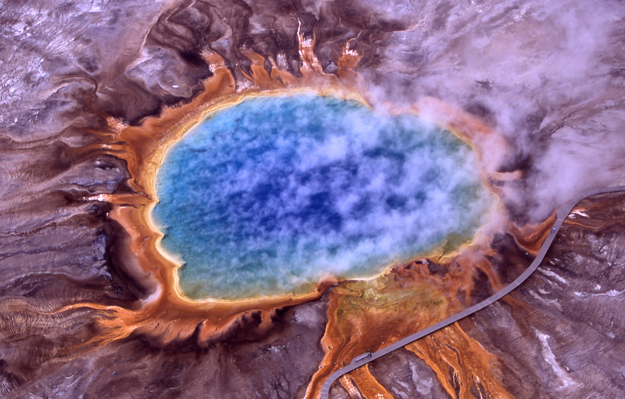
Grand Prismatic Spring, Hot Springs, Midway and Lower Geyser Basin, Yellowstone National Park, aerial view showing steam rising from hot and sterile deep azure blue water in the center surrounded by huge mats of brilliant orange algae and bacteria: photo by Jim Peaco, 2001 (US National Park Service)

Detroit, with Windsor, Ontario across the Windsor River: simulated-color satellite image by Landsat 7 (NASA)

Brazzaville, Kinshasa and the Malebo Pool of the Congo River: satellite photo by NASA, 2005
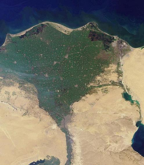
Nile River Delta: MISR satellite image, 2001 (NASA)

Nile River Delta from orbit: MODIS Rapid Response Team, NASA/GSFCMISR satellite image by Jacques Descloitres, 2003 (NASA)
- (NASA caption: Against the barren desert of northeastern Africa, the fertile valley of the Nile River runs northward through Egypt. In the higher-resolution images, the city of Cairo can be seen as a gray smudge right where the river widens into its broad fan-shaped delta. Other cities are dotted across the green landscape, giving it a speckled appearance. Where the Nile empties into the Mediterranean Sea (top) the waters are swirling with color, likely a mixture of sediment, organic matter, and possibly marine plant life. Farther west, the bright blue color of the water is likely less-organically rich sediment, perhaps sand. East of the delta lies the arid Sinai Peninsula, whose pointed tip is home to rugged mountains, some as high as 8,600 feet. The lattice work of pale lines marks the paths of ephemeral rivers. The Sinai Peninsula intrudes into the Red Sea. Farther east are Israel, Jordan, and Saudi Arabia. At top right is the disputed territory of the West Bank. In the false-color image, vegetation is bright green, water is dark blue or black, and clouds are light blue. It's interesting to notice that places that seem essentially arid, or desert-like in the true-color image in fact have a delicate layer of vegetation. For example, the central Sinai Peninsula, and most of Israel have a faint greenish tinge in the false-color images.)

Nile River Delta at night: satellite photo by ISS Expedition 25 crew, 2010
(NASA caption: In this view of Egypt, we see a population almost completely concentrated along the Nile Valley, just a small percentage of the country’s land area.The Nile River and its delta look like a brilliant, long-stemmed flower in this astronaut photograph of the south-eastern Mediterranean Sea, as seen from the International Space Station. The Cairo metropolitan area forms a particularly bright base of the flower. The smaller cities and towns within the Nile Delta tend to be hard to see amidst the dense agricultural vegetation during the day. However, these settled areas and the connecting roads between them become clearly visible at night. Likewise, urbanized regions and infrastructure along the Nile River becomes apparent. Another brightly lit region is visible along the eastern coastline of the Mediterranean — the Tel-Aviv metropolitan area in Israel (image right). To the east of Tel-Aviv lies Amman, Jordan. The two major water bodies that define the western and eastern coastlines of the Sinai Peninsula — the Gulf of Suez and the Gulf of Aqaba — are outlined by lights along their coastlines (image lower right). The city lights of Paphos, Limassol, Larnaca and Nicosia are visible on the island of Cyprus (image top). Scattered blue-grey clouds cover the Mediterranean Sea and the Sinai, while much of north-eastern Africa is cloud-free. A thin yellow-brown band tracing the Earth’s curvature at image top is air-glow, a faint band of light emission that results from the interaction of atmospheric atoms and molecules with solar radiation at approximately 100 kilometres altitude.)

Topography of Arabian Peninsula, with dust blowing across Persian Gulf: satellite photo by SeaWIFS (mage by John Nevard, 2008)

Topography of Africa: satellite image by NASA/JPL-Caltech, 2007 (NASA)
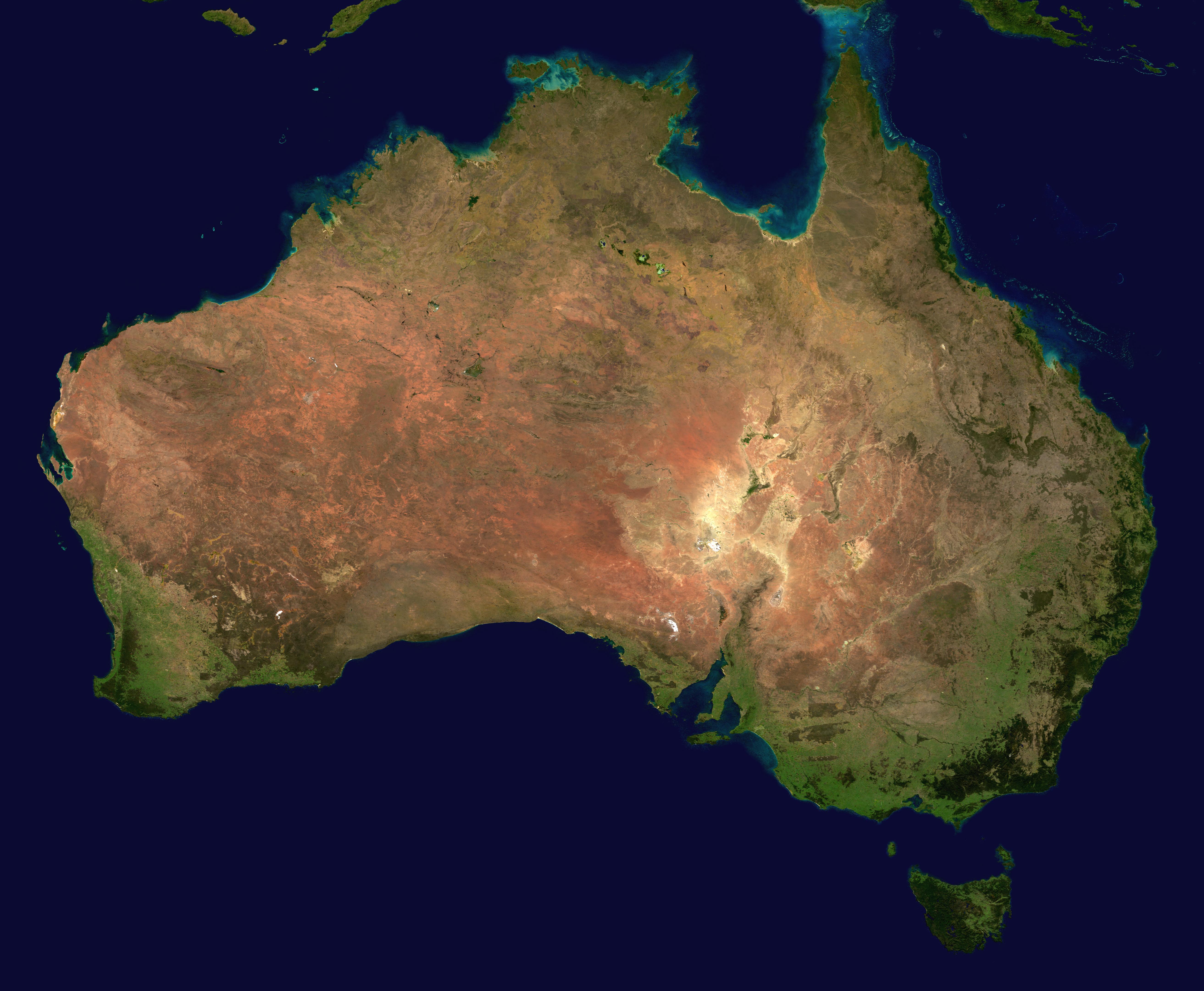
Australia: composite satellite photo by Terra/MODIS, 2002 (NASA)

Fedchenko Glacier, Pamir Mountains, Tajikstan: natural color satellite image by Landsat 7, 2005 (NASA)

Bahama Banks (submerged carbonate platforms that make up much of the Bahama Archipelago -- the northern one is the Little Bahama Bank, and the southern the Great Bahama Bank; the Cay Sal Bank is also visible) with Cuba in the lower area of the image; Andros island is seen in the center, surrounded by the bright blue halo of the Great Bahama Bank, a limestone platform slowly inundated by rising sea levels between 10,000 and 25,000 years ago, as the last ice age glaciers were melting: satellite image by MODIS, 2002 (NASA)

Atacama desert, northern Chile; covering a 600-mile strip of land on the Pacific coast of South America, the driest desert in the world: World Wind 1.4 satellite image by NASA, 2008 (NASA)

Dendi Caldera (formed by the near-total eruption of magma from beneath the volcano, leading to collapse of the volcanic structure into the now-empty magma chamber), on the Ethiopian Plateau, approx. 86 km. southwest of Addis Ababa, Ethiopia: photo by ISS Expedition 16 crew, 2007 (NASA)

Topography of Viti Levu, Fiji's largest island: satellite image by NASA/JPL/NIMA, 2000 (NASA)


4 comments:
I'm sure there are words. I just haven't found them yet.
Curtis, a loss for words here too.
To attempt to remove one's view of things to as great a distance as possible from the immediate physical situation one's in wasn't built in a day, of course.
But pictures of the world from almost any distance do take one's mind off the not-worlds, if only a bit, if only intermittently.
Anyway it all looks so -- real, is that the lost word? -- from up there.
Tom,
one's view of things . . . immediate physical sensation . . . pictures of the world . . . all looks so -- real . . .
1.22
light coming into sky above still black
trees, waning white moon next to branch
in foreground, sound of wave in channel
sunlit plane of ridge below
pale blue sky, moment
bird moving from fence post,
lavender, bird feeder
silver of sunlight reflected in channel,
whiteness of gulls gliding across ridge
Amazing collection of photos, Tom. Here's a word: "yokeyme"
Post a Comment