.

View from Tater Knob in the Daniel Boone National Forest, Cumberland region, eastern Kentucky: photo by Mzzl, 21 August 2005
Boone, John Findley, John Stewart and three others left the Upper Yadkin for Kentucky on May 1, 1769, their equipment packed on ten or fifteen horses. The men ascended the mountains along Elk Creek through the present village of Darby, North Carolina, crossed the Blue Ridge, then descended into the high meadow. They continued north and west through a series of gaps, over Stone Mountain and Iron Mountain, leading them to the Holston River. There the hunters connected with the Great Warrior's Path, and their direction shifted due west, crossing a series of Appalachian ridges and valleys, formed by the waters of the Upper Tennessee River. By 1769 this trail had been worn by the passing of an increasing number of hunters. It took them across Moccasin Gap to the Clinch River valley, then over Powell's Mountain and Wallen's Ridge to the valley of the Powell River, where they encountered a group of twenty men under the leadership of Joseph Martin, clearing land for a crop of corn. This was the westernmost settlement yet attempted, and, outraged at this movement into their territory, the Cherokees would break up Martin's settlement before the corn was ripe. From there Boone's men traveled south along the river to the tall cliffs of the Cumberland Mountains known as White Rocks, traditional markers for the Cumberland Gap, the most famous pass in all of North America.
This great V-shaped notch in the mountain wall was long the primary gateway to the West. "Stand at Cumberland Gap," wrote Frederick Jackson Turner in his famous essay on the significance of the frontier in American history, "and watch the procession of civilization, marching single file -- the buffalo following the trail to the salt springs, the Indian, the fur-trader and hunter, the cattle-raiser, the farmer -- and the frontier has passed by." Boone was by no means the first to pass through this narrow defile; travelers on the Great Warrior's Path had used the gap for hundreds of years. But it was the effort of Daniel Boone that would bring the pass to popular attention, and eventually more than three hundred thousand settlers would follow this route to Kentucky and beyond.

West of the gap the trail shifted northward to the crossing of the Cumberland River, then northwest to an old Indian camping ground at Flat Lick. From this point the Great Warrior's Path veered north (leaving modern U.S. 25E behind, heading through the rough terrain of the Daniel Boone National Forest.) Today the entire trip from the Yadkin to the Bluegrass occupies no more than a couple of leisurely hours of driving, but these men had been traveling hard for five weeks and must have begun to wonder if Findley's promised land actually existed. But passing through Sand Gap, a slight depression in the ridge separating the Cumberland and Kentucky rivers, they soon glimpsed the end of the mountains and began a gradual descent into the region known as the Knobs, where conical hills provide views of the rolling hill country beyond. Knowing that they had reached Kentucky at last, they picked a site for their base camp. Station Camp, as it was called, was a location he Shawnees knew as Ah-wah-nee (deep grassy place), two or three miles south of the present-day town of Irvine. Nearby, the towering formation now called Pilot Knob provided a commanding view of the rolling country that lay to the northwest. It was covered with forest, but cane, a variety of bamboo indigenous to North America, grew in wide swaths along the watercourses, and there were extensive grassy meadows.
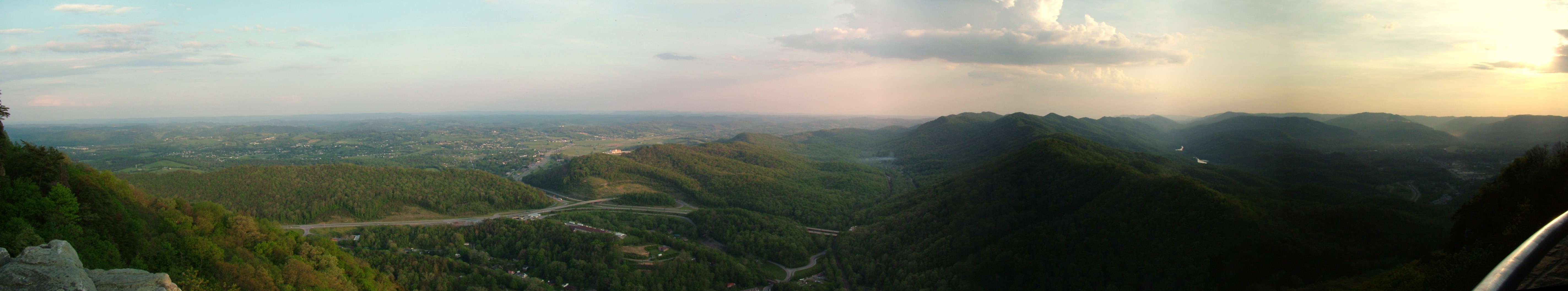
This great V-shaped notch in the mountain wall was long the primary gateway to the West. "Stand at Cumberland Gap," wrote Frederick Jackson Turner in his famous essay on the significance of the frontier in American history, "and watch the procession of civilization, marching single file -- the buffalo following the trail to the salt springs, the Indian, the fur-trader and hunter, the cattle-raiser, the farmer -- and the frontier has passed by." Boone was by no means the first to pass through this narrow defile; travelers on the Great Warrior's Path had used the gap for hundreds of years. But it was the effort of Daniel Boone that would bring the pass to popular attention, and eventually more than three hundred thousand settlers would follow this route to Kentucky and beyond.
Panoramic view from Pinnacle Overlook at Cumberland Gap National Historic Park: photo by Stratosphere, May 2007
West of the gap the trail shifted northward to the crossing of the Cumberland River, then northwest to an old Indian camping ground at Flat Lick. From this point the Great Warrior's Path veered north (leaving modern U.S. 25E behind, heading through the rough terrain of the Daniel Boone National Forest.) Today the entire trip from the Yadkin to the Bluegrass occupies no more than a couple of leisurely hours of driving, but these men had been traveling hard for five weeks and must have begun to wonder if Findley's promised land actually existed. But passing through Sand Gap, a slight depression in the ridge separating the Cumberland and Kentucky rivers, they soon glimpsed the end of the mountains and began a gradual descent into the region known as the Knobs, where conical hills provide views of the rolling hill country beyond. Knowing that they had reached Kentucky at last, they picked a site for their base camp. Station Camp, as it was called, was a location he Shawnees knew as Ah-wah-nee (deep grassy place), two or three miles south of the present-day town of Irvine. Nearby, the towering formation now called Pilot Knob provided a commanding view of the rolling country that lay to the northwest. It was covered with forest, but cane, a variety of bamboo indigenous to North America, grew in wide swaths along the watercourses, and there were extensive grassy meadows.
While Stewart supervised the construction of the camp, Boone and Findley followed the Warrior's Path further north in search of Blue Lick Town. Crossing the Kentucky and Red rivers, less than twenty miles from Station Camp, they found it abandoned and mostly burned. In the fields, however, the two men found bluegrass growing in abundance. Bluegrass is not native to America but is an English import, sometimes known as timothy. Yet the first Americans to reach central Kentucky found it growing in the rich limestone soil at a number of locations, and the region soon came to be known as the Bluegrass. Boone's nephew Daniel Boone Bryan suggested that the grass was first introduced to the West by John Findley, who packed his trade goods in English hay at Lancaster, Pennsylvania; throwing the packing aside after reaching his destination, the seed sprouted and grew. Other traders surely did the same. The action of buffalo, deer and other grazing animals then spread the seed to other clearings and licks. At the site of Blue Lick Town, Findley recovered his bearings and was able to provide Boone with a mental map of the land. Moving up the creek that watered Blue Lick Town, they climbed to a spot known locally as Pilot View, and, in the words of Filson's Boone, "from the top of an eminence, we saw with pleasure the beautiful level of Kentucke. We found everywhere abundance of wild beasts of every sort, through this vast forest. The buffalo were more frequent than I have seen cattle in the settlements, browsing on the leaves of the cane, or cropping the herbage of those extensive plains." Recounting a family tradition, one of Boone's grandchildren later wrote that as Boone looked out over this scene, he exclaimed to Findley, "We are as rich as rich as Boaz of old, having the cattle of a thousand hills."

Daniel Boone Escorting Settlers through the Cumberland Gap: George Caleb Bingham, 1851-1852 (image by Wilking79, 2009)
Daniel Mack Faragher: Daniel Boone (excerpt), 1992


4 comments:
Some scenes from The Late Life of Mr. Boone.
recommended on the West
Undaunted Courage by Steve Ambrose
on Lewis and Clark...
the author once having given me
a tip to avoid the ravages of
the law
Elmo, that's a book that sounds as though it has the dimensions of a life.
This taste has whetted my interest.
"This book has been a labor of love. We have endured summer snowstorms, terrible thunderstorms in canoes on the Missouri and Columbia rivers, soaking rains on the Lolo, and innumerable moments of exhilaration on the Lewis and Clark Trail. The Lewis and Clark experience has brought us together so many times in so many places that we cannot measure or express what it has meant to our marriage and our family."
And by the by, I'm sure you would love the Faragher book about Boone. It's an enthralling tale of discovering the great beauties and mysteries of what was then virgin country, that Cumberland region of knobs and peaks, in all the wildness of what it was before the real estate and extraction interests moved in -- motivating Boone to keep on moving west ahead of the acquisitive tide, into that part of the world you now know so much better than the rest of us ever will.
What D. Boone would have made of "mountaintop-removal" (strip mining) shearing off all the tops of the mountains of eastern Appalachia for the original Yankee reason, a quick killing, one might only guess.
There's the lovely anecdote about Boone, in his old age, by then removed to the Osage Country, watching from the shore as the Lewis and Clark party started up the Missouri. Successive epochs of the advance into the interior, that grand, fateful story.
Cumberland
rEALLY THANKS FOR THIS ITS REALLY AMAZED FOR ME AT LEAST !!!!!
Post a Comment