.
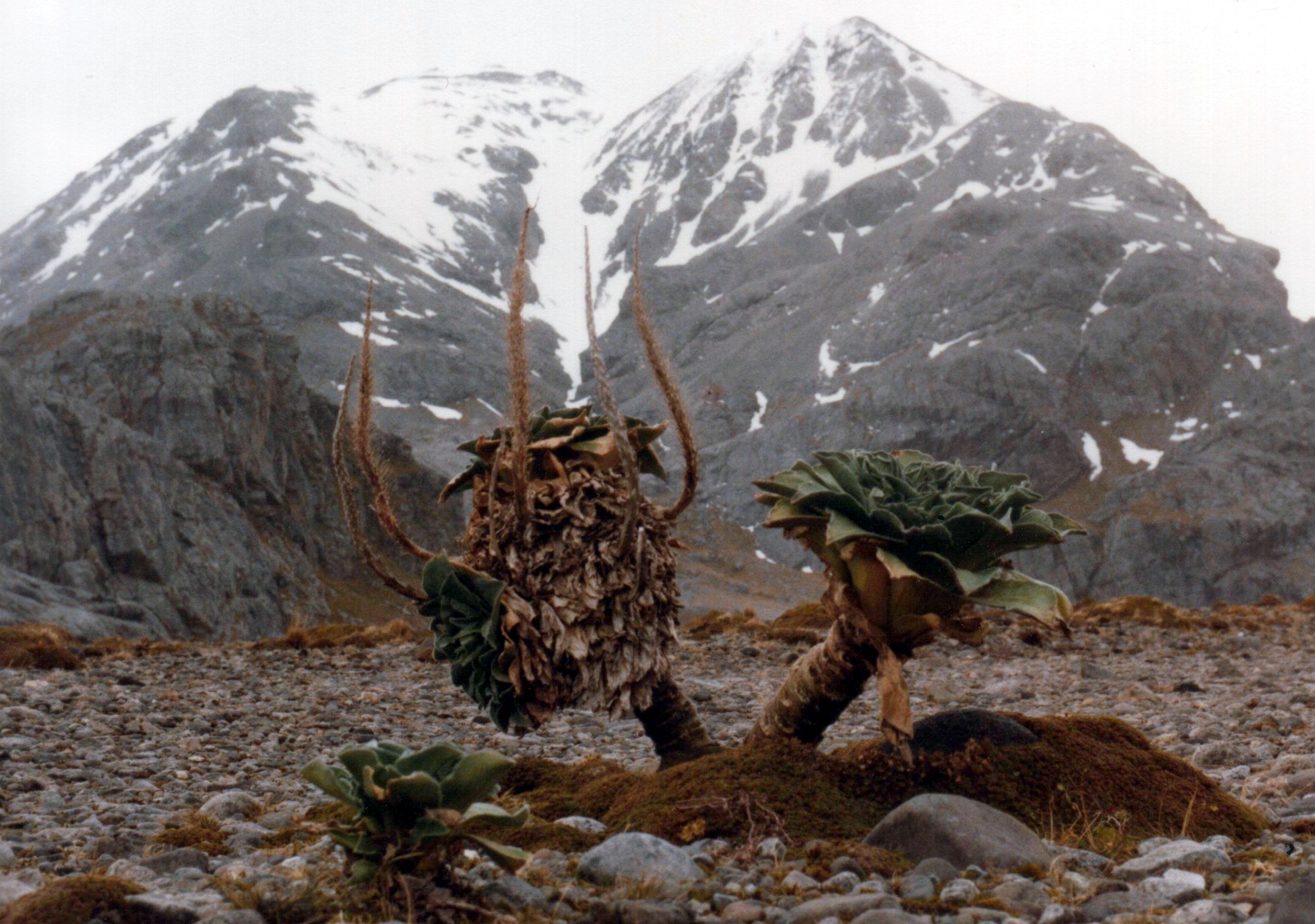
Kerguelen's Cabbage (Pringlea antiscorbutica), old plant, Peninsula Rallier du Baty, Kerguelen Islands: photo by Denis Barthel, 1983; image by B. navez, 2008
The Island of Desolation: Cook's Third Voyage, aboard the Resolution in the southern ocean, December 1776
The land first seen was an islet, Kerguelen's Isle de Croy, off the north-west point of the main island, one of a small group so lying. Cook hauled off round this group, just weathering the high rock he called Bligh's Cap (now Ilot du Rendez-vous). In the afternoon, with a clearer air, the main shore was in view, an extremely indented one; within its northern promontory lay a promising harbour, which Bligh reported on favourably; and the next day the ships worked up inside almost to the sandy beach at the head. He called the place Christmas Harbour. It was Kerguelen's Baie de l'Oiseau, and retains this name; but Cook, with the sketchy chart he had had, and altogether ignorant of Kerguelen's second voyage, may be excused for making some wrong identifications, and even for being surprised at finding himself preceded here. There was plenty of water -- the whole country was running with it -- but not a tree or a shrub or a piece of driftwood; plenty of penguins, innumerable other sea-birds, and seals whose lack of sophistication made it easy to club them for their oil; a little grass for the cattle; few fish; so really the harbour's promise was a little illusory, except for shelter. The men, however, were given a day off for a Christmas celebration, and one of them brought back a bottle he had found attached to a rock on the north side. It contained a Latin inscription on parchment recording French visits to the country in 1772 and 1773 (though the French officer who left this record did not land until January 1774). Cook had a new inscription put on the other side -- Naves Resolution & Discovery de Rege Magnae Britanniae Decembris 1776 -- and returned it to the bottle with a silver twopenny piece, built a pile of stones on a little rise and put the bottle inside; displayed the British flag and gave the place the name he chose. Whether that signified the 'ridiculous' act of taking possession, as the philosophic Anderson feared it did, we are left to guess.

Kerguelen's Cabbage (Pringlea antiscorbutica), Peninsula Rallier du Baty, Kerguelen Islands: photo by B. navez, 18 August 2005
So on the afternoon of that day, 28 December, he went on to the high cape that guarded the harbour in the north, to get a view of the coast. Fog hid all, except the higher land within, quite naked and desolate, and some snow-covered hills to the south. Next morning he left the harbour, and fortunately the fog cleared, the sea was still. There followed two days of such intense coastal observation that at the end of his close-packed pages one realises with difficulty that this is the harvest of two days indeed, and not a week. On the whole this observation of a tortuous shore was accurate, and the greater number of the names Cook gave have survived; and glad we are to find not merely those of royalty and naval personages, not merely the inevitable Sandwich, laid upon the ocean from one end to the other, but 'Point Pringle after my good friend Sir John Pringle Precedent of the Royal Society'. At the end of a day of clearing forelands, islets, rocks, shoals, and even threading the channels between the great beds of kelp, with the lead going all the while, with fog threatening again, the ships put into a small harbour which gave snug enough shelter for the night -- Port Palliser. Cook climbed a hill as usual for the view -- daylight was long -- Gore looked at the land, the masters sounded. Barrenness and desolation again, nothing for cattle, only water, seals, and sea birds for men. So to sea again, and the sight of a lower, more level, less indented piece of country, backed by rocky mountains topped by snow, until Cook had in sight what he was persuaded must be the most southerly point of the land; as night came on a south-west swell added to his conviction that there was no more in that direction, and the wind shifting to the same quarter he stood away from the coast eastwards.

Captain James Cook's map of Kerguelen's Land, or Island of Desolation: from Cook's Expedition of 1784 (National Library of Australia)
Well: he must summarise his impressions, geographically. The first discoverers, 'with some reason', had imagined the country to be a the projection of a southern continent; 'the English' had since proved that no such continent existed. The country, then, was an island; if any further proof of its limited extent were needed, that could be found in Furneaux's track in 1773, for he had passed it only about seventeen leagues off Cook's most southerly cape and seen nothing. So in latitude it could not much exceed one degree and a quarter -- a remarkably accurate estimate. As to the longitude of its western end he could not say, but it could not stretch as far as 65 degrees E; for he had searched to that point in 1773. And a name? 'Kerguelen's Land', or Kerguelen Island, was not the name he gave: 'from its stirility' he would call it the Island of Desolation. For its natural history he would fall back on Anderson, who had made good use of his four days at Christmas Harbour, and wrote on soil and rocks, the Kerguelen cabbage that he called Pringlea -- he too celebrating the President -- the few other small plants and mosses; three different penguins, clearly described; shags, ducks, albatrosses, three different penguins; an uninviting fish; the fur seal. What could be eaten was eaten. When the captain looked at his own stock, he could feel even less joy. The young bulls, one of the heifers, the rams, most of the goats, bought at at the Cape had died. The islands, it was plain, could not be easily supplied. The animals that were left still ate. Whatever the feelings of animals, there was some relief for men in leaving 'this Cold Blustering Wet Country' (the words of Gore), and 'the Melancholy Croaking of Innumerable Penguins' (the words of Edgar), and steering a course for New Zealand.
J. C. Beaglehole: The Life of Captain James Cook, 1974: from Chapter XX, England to New Zealand Again
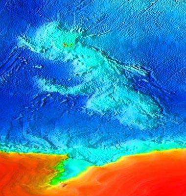
Topographical map of the submerged Kerguelen micro-continent, formed c. 110 million years ago from a series of large volcanic eruptions; the red patch below the suboceanic Kerguelen plateau is the continent of Antarctica. Much of the plateau was above sea level for three periods between 100 million years ago and 20 million years ago. The so-called Kerguelen microcontinent may have been covered by dense conifer forest in the mid-Cretaceous period. It finally sank 20 million years ago and is now 1–2 km (0.62–1.2 mi) below sea level. The presence of sedimentary rocks similar to those found in India and Australia suggests the landmasses were once connected: image by Wiz9999, 10 May 2007 (NOAA)

Southern Elephant Seals (Mirounga leonina), young, moulting, northern shore of Kerguelen Islands: photo by B. navez, 21 August 2005

Light-mantled Albatross (Phoebetria palpebrata), Peninsula Rallier du Baty, Kerguelen Islands: photo by Dimitri Damasceno, 20 September 2004 
Rockhopper Penguins (Eudyptes chrysocome), Kerguelen Islands: photo by B. navez, 1983/2005

Southern Elephant Seal (Mirounga leonina), male, northern shore of Kerguelen Islands: photo by B. navez, 1999


5 comments:
Today I've been revisiting both of the new posts periodically because the images, colors, titles and their juxtaposition with the text (which I only was able to skim lightly) were so arresting. Then I determined to read through this before heading off to bed. It was so gripping, took my imagination in so many directions, and helped re-order my disordered "agenda," for which I'm grateful. Curtis
I meant to add that Kerguelen's Cabbage is extraordinary looking (seeming to be both earthly and extra-terrestrial in origin) and it so fits the lost/micro-continent context. "'from its stirility' he would call it the Island of Desolation". Curtis
P.S. Blogger seems to be acting up again. I really hope it isn't. C.
Curtis,
On a cold sodden night of continuous rain here on the Lost Continent, it is very pleasant to feel the warmth of your company.
The maddening and apparently whimsical misconduct of these lab pixies to whom we must offer the sacrifice of our time and trouble in order to have the honour of providing "content" to the Cloud is so infuriating that one hesitates even to acknowledge their brainless power.
In fact for the past week there has been the feeling of being lost at sea in the aether with neither a great navigator like Cook to guide us nor a helpful (and ancient) antiscorbutic cabbage on hand to relieve the symptomatic effects of the overlong voyage into the fog.
Of course in the distant geological view, entire continents have arisen and fallen and will rise and fall again without anyone to remark the fact; and in this timeframe, our own skewed agendas probably figure less prominently than would a patch of lichen on Kerguelen Island.
However, that patch of lichen would at least have the satisfaction of being microbe-free.
"Stirility" may indeed simply be another way of saying "clean".
Tom and Curtis,
Yes, and a pleasure too to start the day after such rain as last night's, with sunlight now pouring down above the tops of clouds -- and to imagine such voyages of exploration, map making, cabbage and lichen finding, ships under sail gone from home for long stretches of time, being there on the shores of that desolate Lost Continent. . . .
5.15
silver edge of grey cloud above shadowed
plane of ridge, blackness of pine branch
in foreground, waves sounding in channel
in connection with the word,
ground for this “fact”
picture’s world, looking at,
time that of being in
grey-white clouds reflected in channel,
shadowed green pine on tip of sandspit
And here, even as I hunt and peck these humble phrases, comes the advance flotilla of the next fleet of storms from... either Desolation Island or the Bering Straits, I can't remember any more.
Thinking of Stephen's love of the sea and Curtis's birding proclivities over the past few nights has now brought about The Sanderlings and Banksia
...
Post a Comment