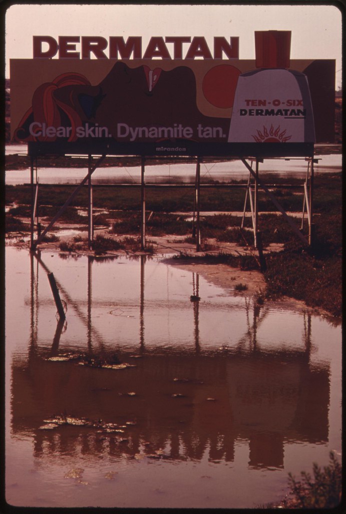
.

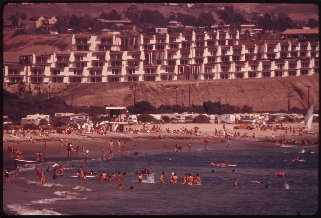
Sunbathers at Huntington Beach, and an oil platform offshore. Nearby a major housing development is under construction, one of relatively few that have been authorized since the implementation of the Coastal Zone Conservation Act in 1973. The commissions, which are charged with determining development along the shoreline, must submit recommendations to the state legislature by January 1976, recommending guidelines for future shoreline development: May 1975
Things To Do in California (1980)
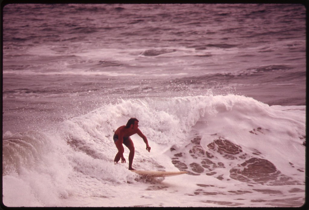
Play beach volleyball
Make surfboards & live at Dana Pt.
Pick up chicks galore
Catch cancer from the chemicals in the water
Die a grotesque death
Have a movie made about your life
Make sure you look good in every scene
Play beach volleyball
Make surfboards & live at Dana Pt.
Pick up chicks galore
Catch cancer from the chemicals in the water
Die a grotesque death
Have a movie made about your life
Make sure you look good in every scene
TC: Things To Do in California (1980), from Under the Fortune Palms, 1982
Surfer at Newport Beach, a heavily used recreation spot. Upper
Newport Bay, north of this area, is scheduled for intensive
development. Development within 1,000 yards of the coastline has been
regulated by state and regional commissions since early 1973: May 1975
New townhouses overlook busy Doheny State Beach. The townhouses represent one of the few construction projects permitted within 1,000 yards of the shoreline after passage of the Coastal Zone Conservation Act in November 1972: September 1974
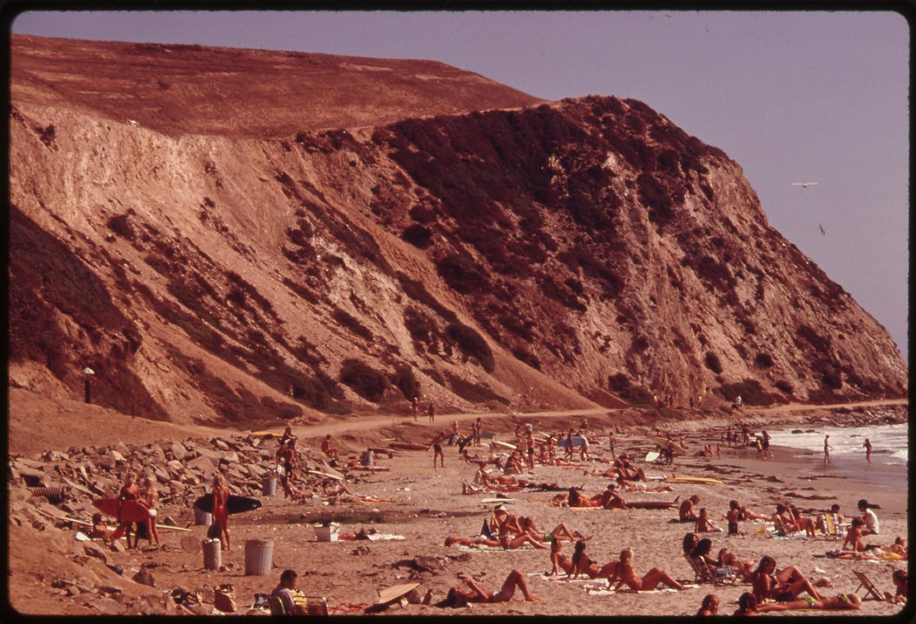
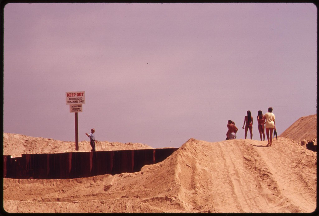
Access to Niguel Beach Park along the ocean in Orange County, is
through an area that was scheduled for development. However
construction was halted when the state passed the Coastal Zone
Conservation Act in November 1972. State and regional regulatory
commissions must present a finial report to the legislature by
January 1976, recommending passage of laws affecting future coastal
development. Some 84 percent of the state residents live within 30
miles of the coast: May 1975

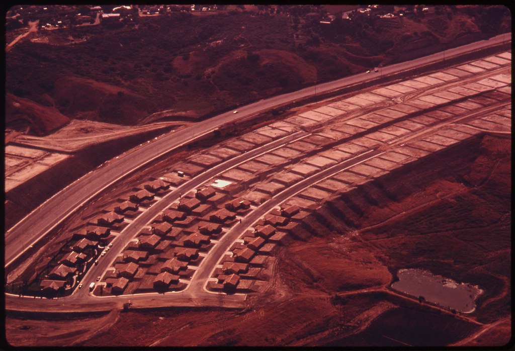
Completed developments at Laguna Niguel, contrast with unfinished streets and utilities (not shown). Development here was halted, and construction elsewhere was restricted following state passage of the Coastal Zone Conservation Act in November 1972: May 1975
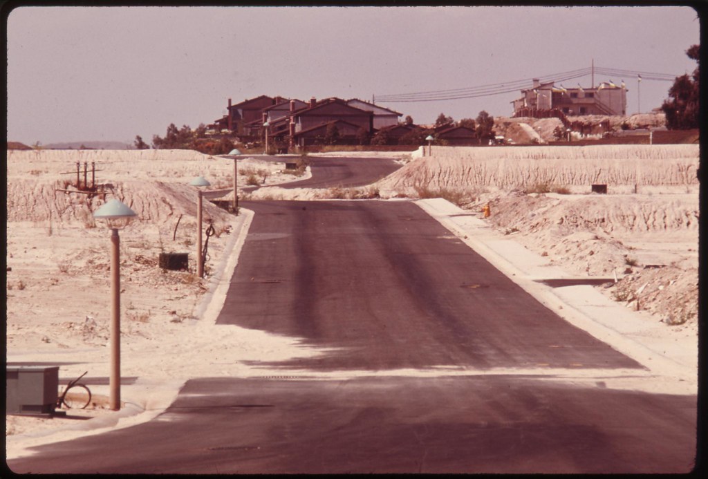
Unfinished streets and utilities contrast with completed development in the background at Laguna Niguel. Work here was halted and other developments were restricted following state passage of the Coastal Zone Conservation Act in November 1972: May 1975
Unfinished streets and utilities contrast with completed development (not shown) at Laguna Niguel: May 1975

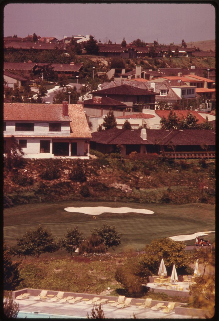
Residential development in the Irvine Ranch area near Newport Beach. This development is part of a new town of high value planned units in contrast to uncontrolled private subdivisions. Some 84 percent of the residents in the state live within 30 miles of the coast. This density results in many clashes between developers and conservationists who want to retain the beauty of the land: May 1975
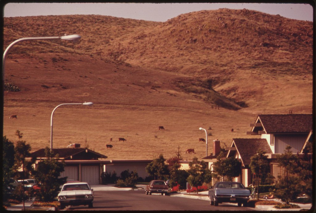
Residential development in the Irvine Ranch area near Newport Beach: May 1975
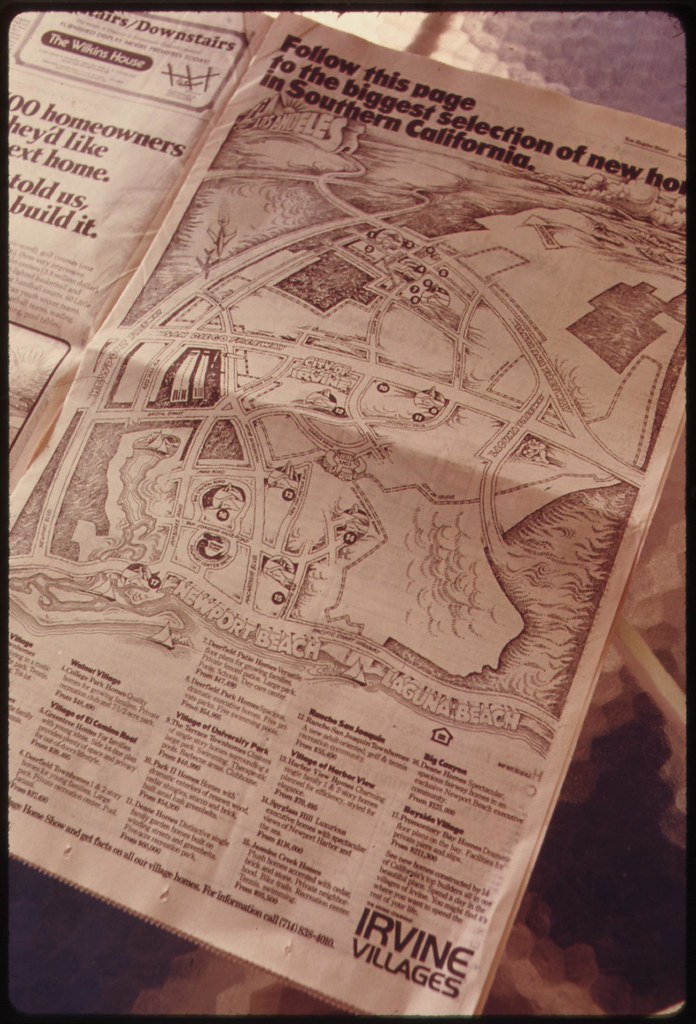
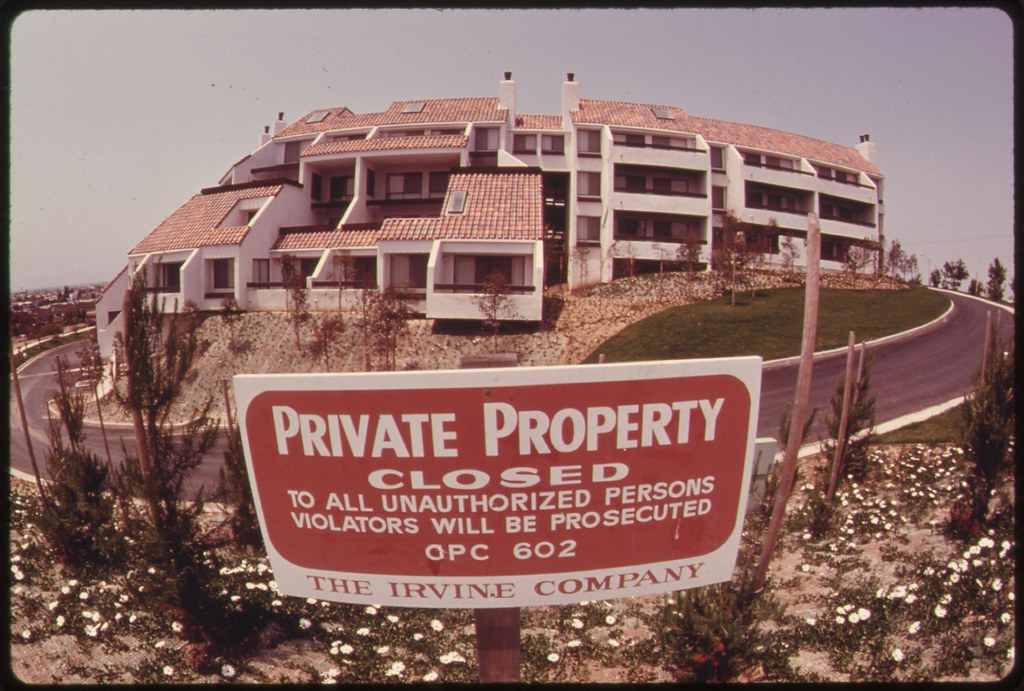
Newspaper advertising in the real estate section of the Sunday issue of the Los Angeles Times directs new home seekers to high value planned unit development by the Irvine company. The firm is building on some of the best land in the seaside county. A state Coastal Zone Conservation Act which went into effect in 1973 has affected all development within 1,000 yards of the shoreline. More stringent construction requirements have resulted in sky-rocketing property values: May 1975
One of only a few construction projects completed along a section of California coastline in Orange County during 1975. Called Promontory Point: May 1975

Sign on a bluff signals the site of a future condominium at Upper Newport Bay in Orange County. It is an area scheduled for intensive development. New construction has been regulated since the implementation in 1973 of the state's Coastal Zone Conservation Act: May 1975
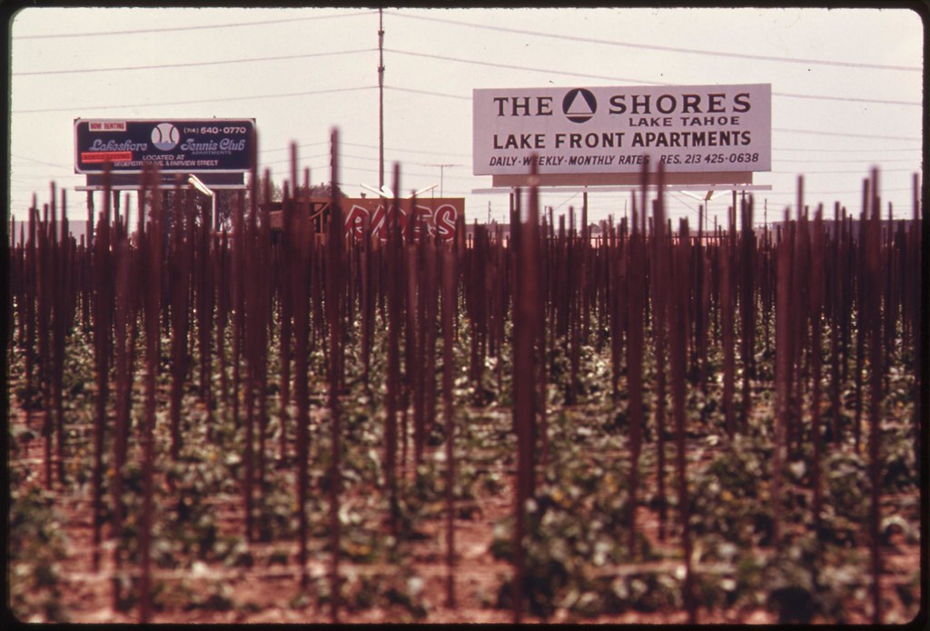
Development signs border one of a few remaining farm fields near the
ocean in fast growing Orange County: May 1975
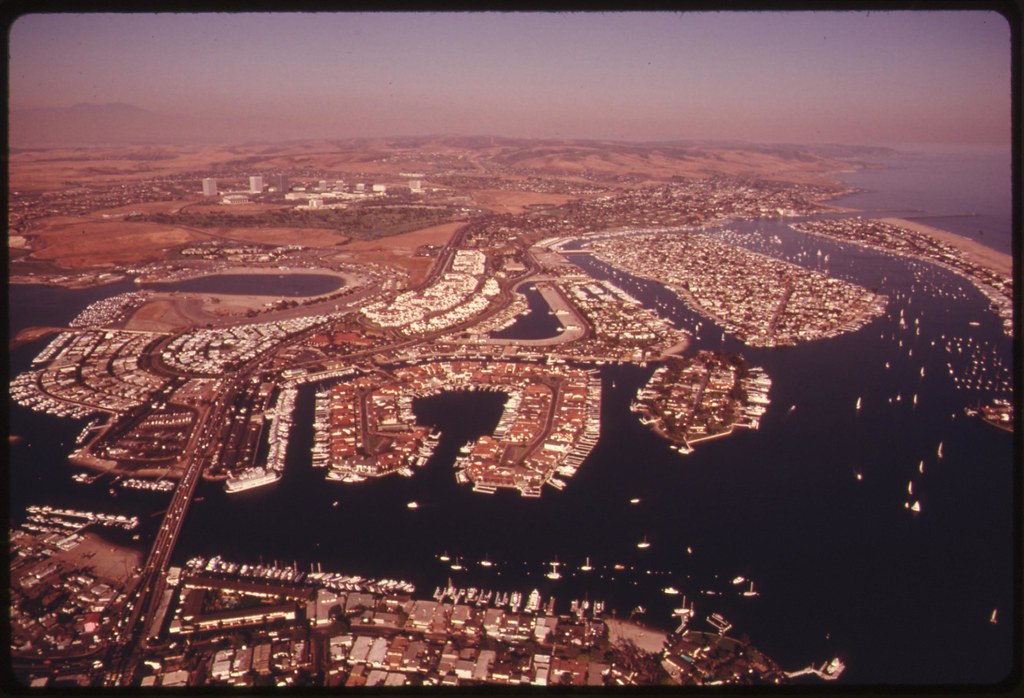
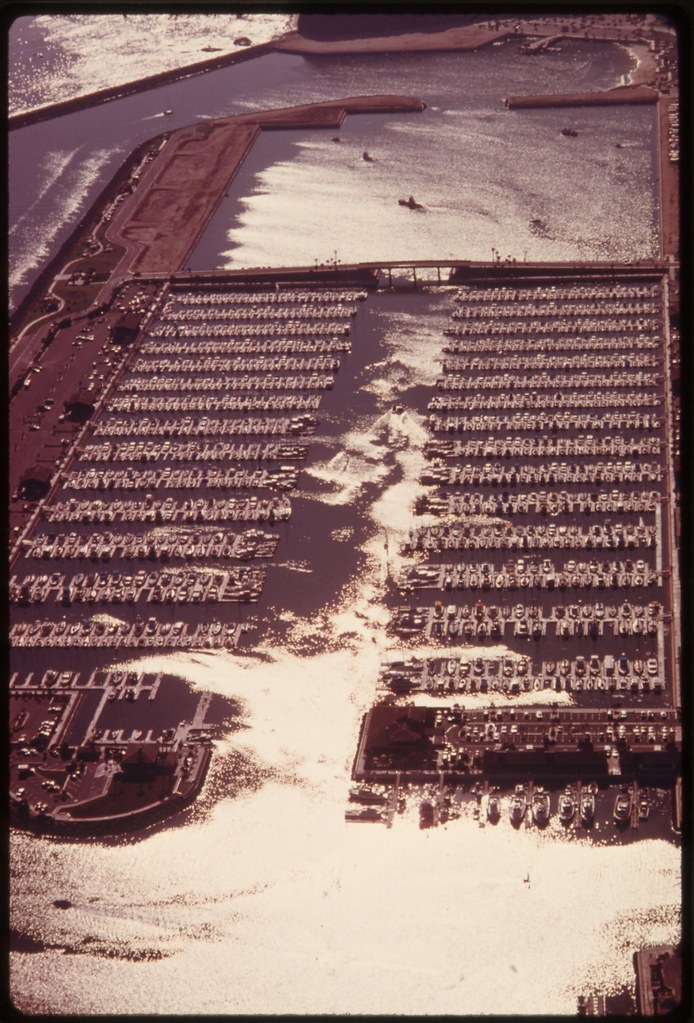
Part of the intensive residential development underway around the harbor as coastal development has come under increasing restrictions since the implementation of the Coastal Zone Conservation Act in 1973: May 1975
Part of the intensive residential development underway around the harbor as coastal development has come under increasing restrictions since the implementation of the Coastal Zone Conservation Act in 1973: May 1975
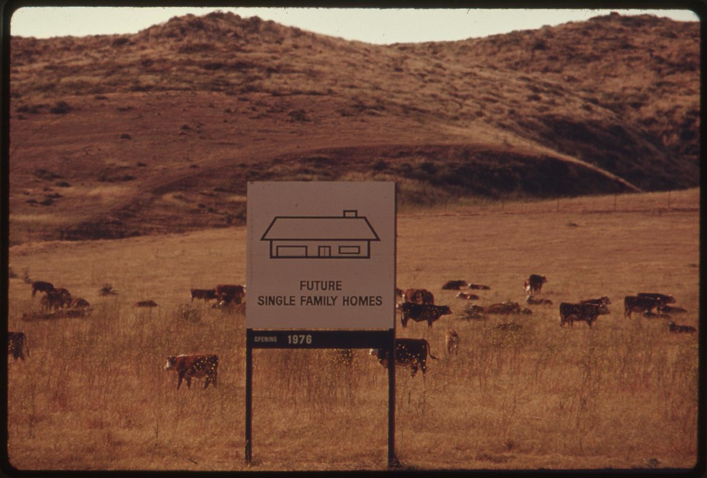
Site of future single family homes scheduled to open in 1976 is shown: May 1975

Marine vehicles on maneuvers along the ocean at the Camp Pendleton base. The shoreline encompassed by the base has retained much of its natural beauty because of limited public access. There are 1,072 miles of mainland shoreline (excluding San Francisco Bay) in the state. Of this total 662 miles of 61 percent is privately owned; the remaining 410 miles is public property. There are some 145 miles under federal control with 47 miles open to the public: May 1975
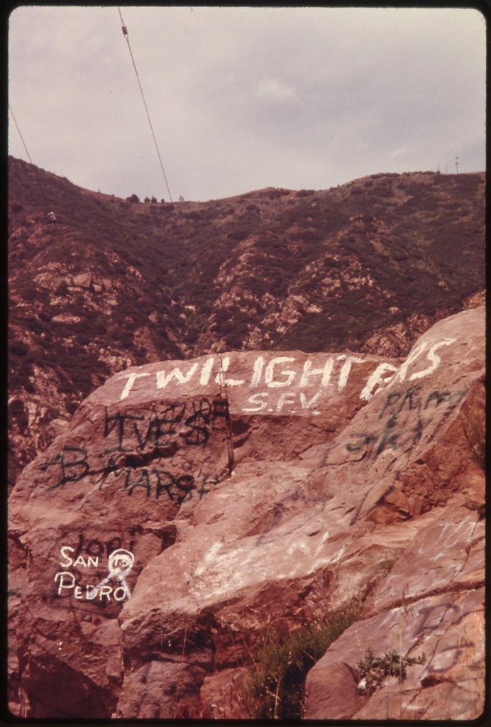
Graffiti defaces rocks in Malibu Canyon near Malibu California, which is located on the northwestern edge of Los Angeles County. The Santa Monica Mountains of which the canyon is a part contain the last semi-wilderness in Los Angeles County, but are threatened by development: May 1975
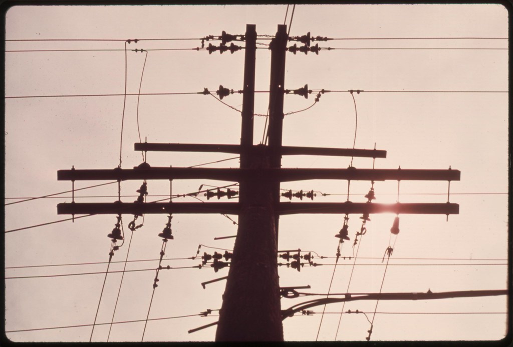
Power pole in the Malibu Canyon area of the Santa Monica Mountains near Malibu, California, which is located on the northwestern edge of Los Angeles County. The mountains contain the last semi-wilderness in Los Angeles County, but are threatened by development: May 1975

Petroleum pipeline signals future development off Mulholland Drive in the Santa Monica Mountains on the western edge of Los Angeles. The mountains contain the last semi-wilderness in Los Angeles County. Some 84 percent of the state's residents live within 30 miles of the coast, and this concentration has resulted in increased land use pressure. Of the 1,072 mile of mainland shoreline (excluding San Francisco Bay), 61 percent is privately owned: May 1975
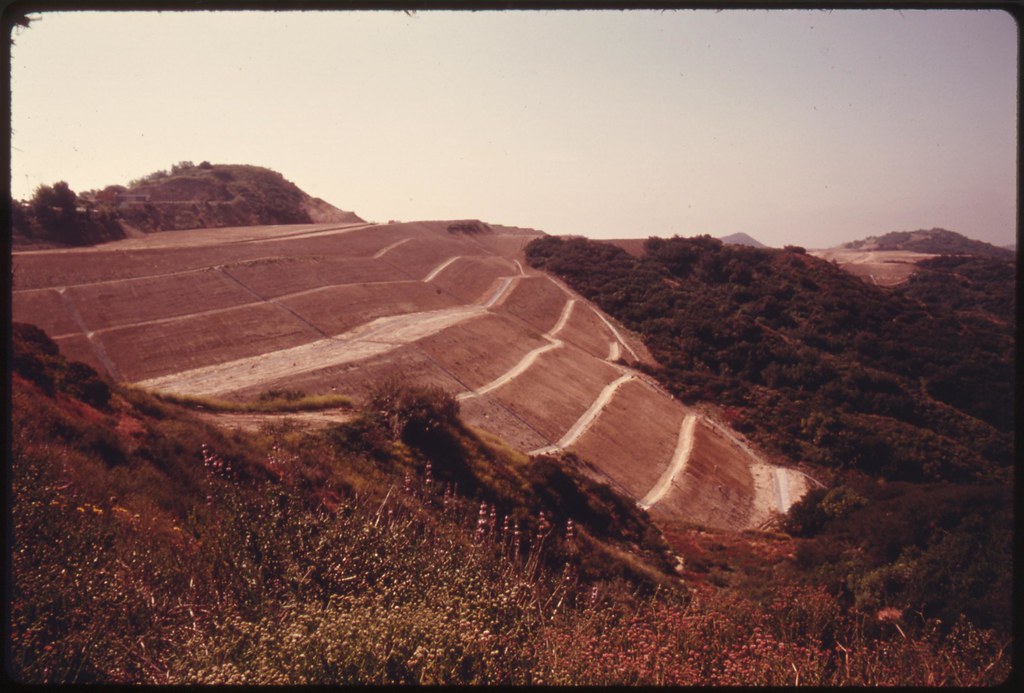
Terraced hillside near Mulholland Drive in the Santa Monica Mountains
on the western edge of Los Angeles portends imminent development. The
mountains contain the last semi-wilderness in Los Angeles County: May 1975
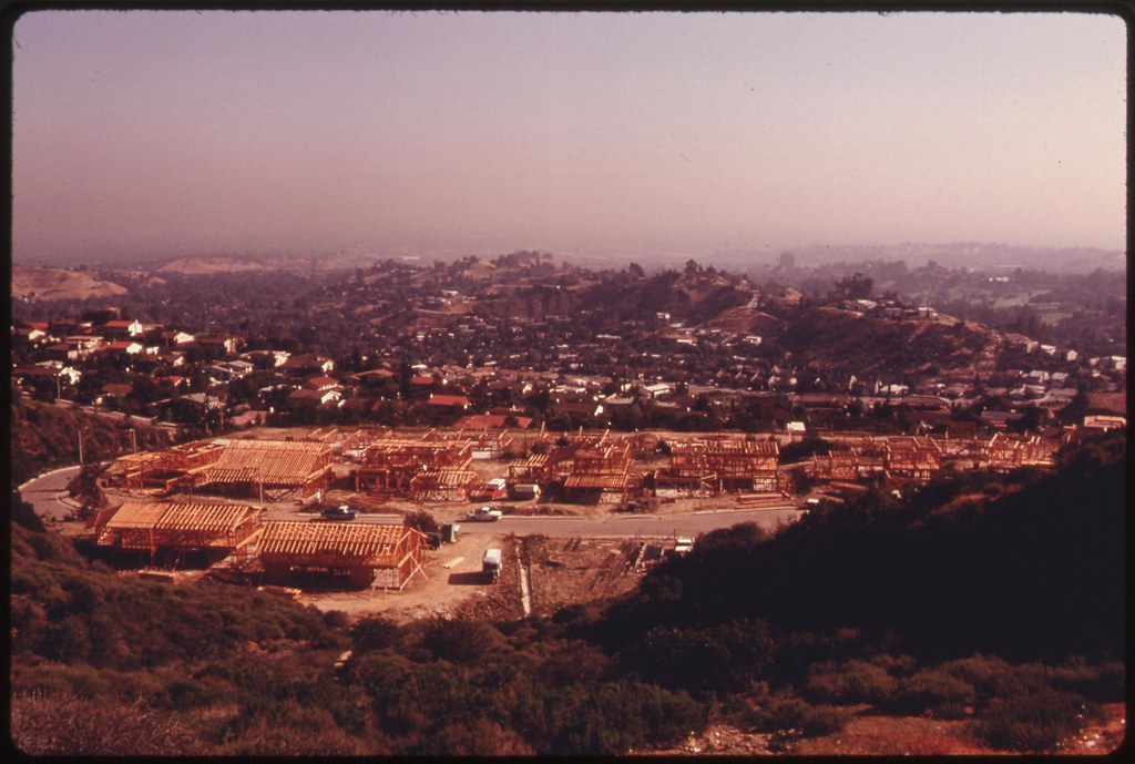
New housing under construction off Mulholland Drive in the Santa Monica Mountains on the western edge of Los Angeles. The mountains contain the last semi-wilderness in Los Angeles County: May 1975
New road and lots awaiting development are seen off Mulholland Drive in the Santa Monica Mountains on the western edge of Los Angeles: May 1975

Seminole Springs Mobile Home Park on Mulholland Drive near Malibu,
California, on the northwestern edge of Los Angeles County is one of
the few developments in the Santa Monica Mountains. The mountains
contain the last semi-wilderness in Los Angeles County: May 1975
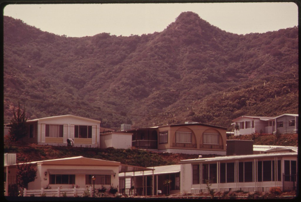
Seminole Springs Mobile Home Park on Mulholland Drive near Malibu,
California, on the northwestern edge of Los Angeles County is one of
the few developments in the Santa Monica Mountains. The mountains
contain the last semi-wilderness in Los Angeles County: May 1975
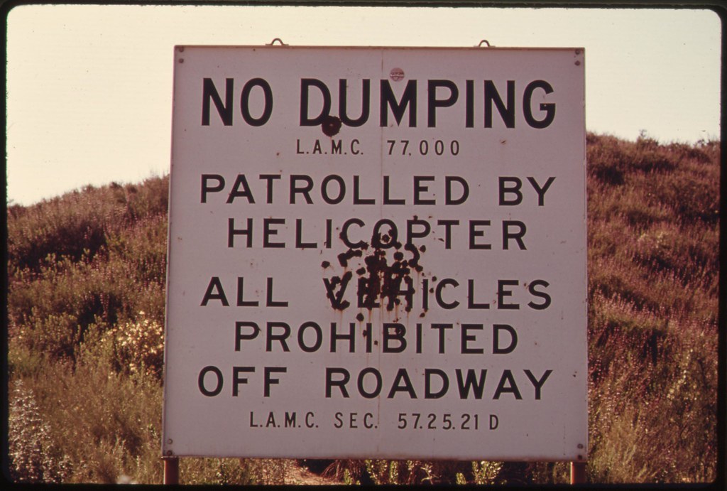
No Dumping sign is a symptom of the population pressures along the
coast of California off Mulholland Drive on the western edge of Los
Angeles. The road winds through the Santa Monica Mountains which
contain the last semi-wilderness in Los Angeles County and are being
threatened by development. Some 84 percent of the state's residents
live within 30 miles of the coast, and this concentration has resulted
in increasing land use pressure: May 1975
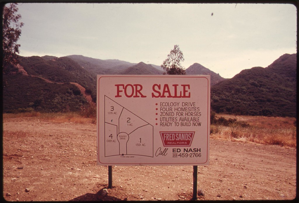
Sign advertises homesites in the Santa Monica Mountains off Mulholland Drive on the western edge of Los Angeles. The mountains contain the last semi-wilderness in Los Angeles County: May 1975
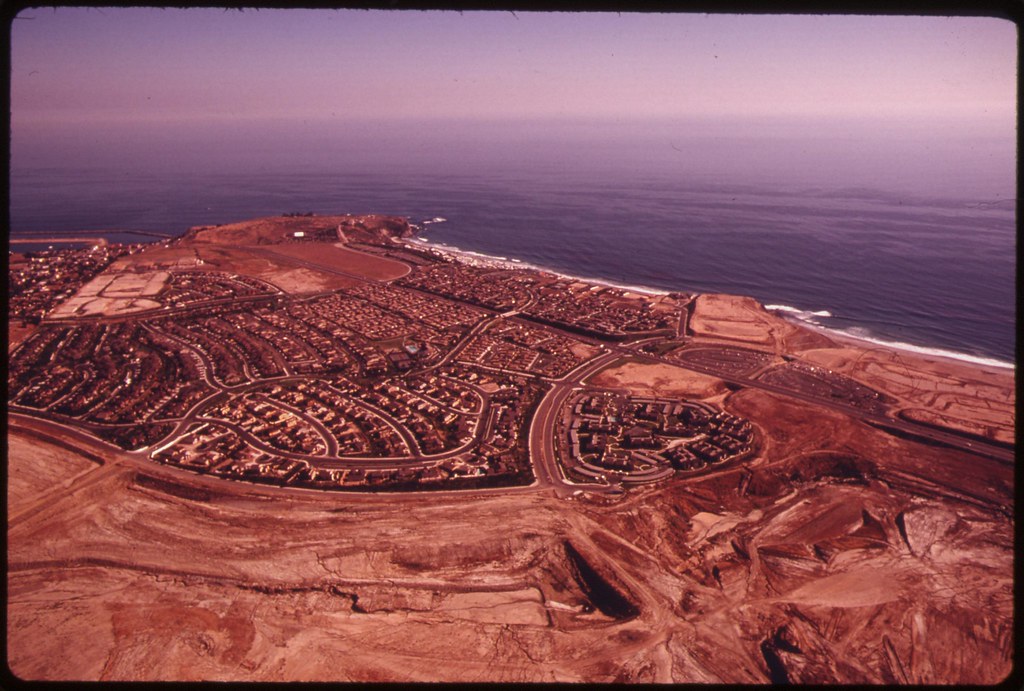
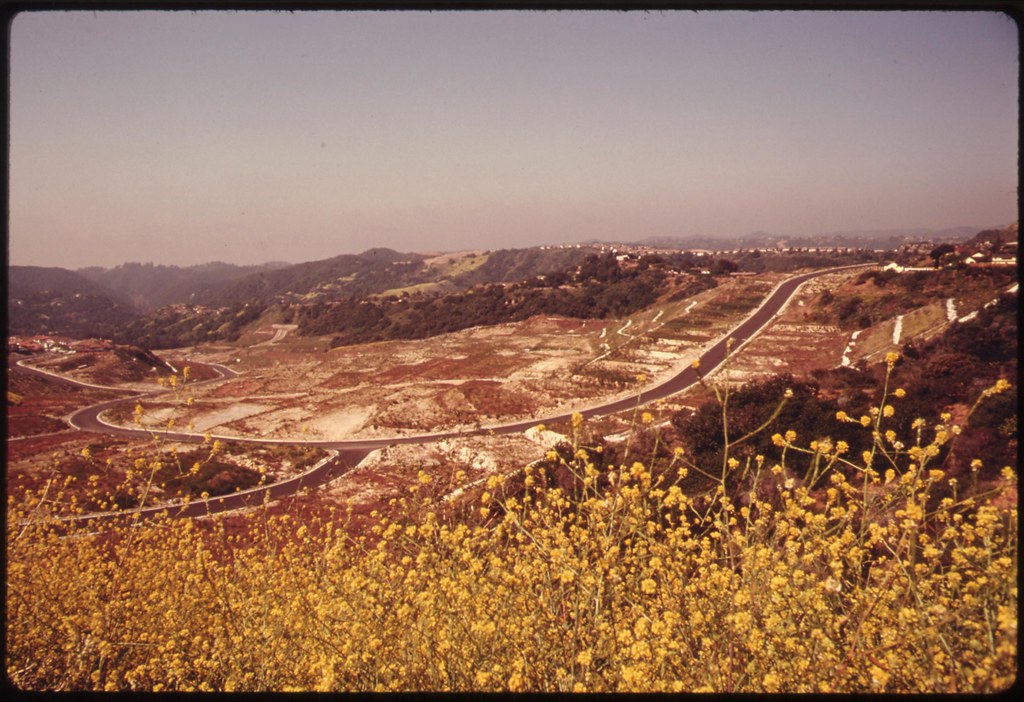
Aerial of land development between Laguna Beach and San Clemente. Work was halted here, and other developments were restricted following state passage in November 1972 of the Coastal Zone Conservation Act. Since 1900 coastal wetlands have decreased from 381,000 acres to about 125,000 acres in the early 1970's: June 1975
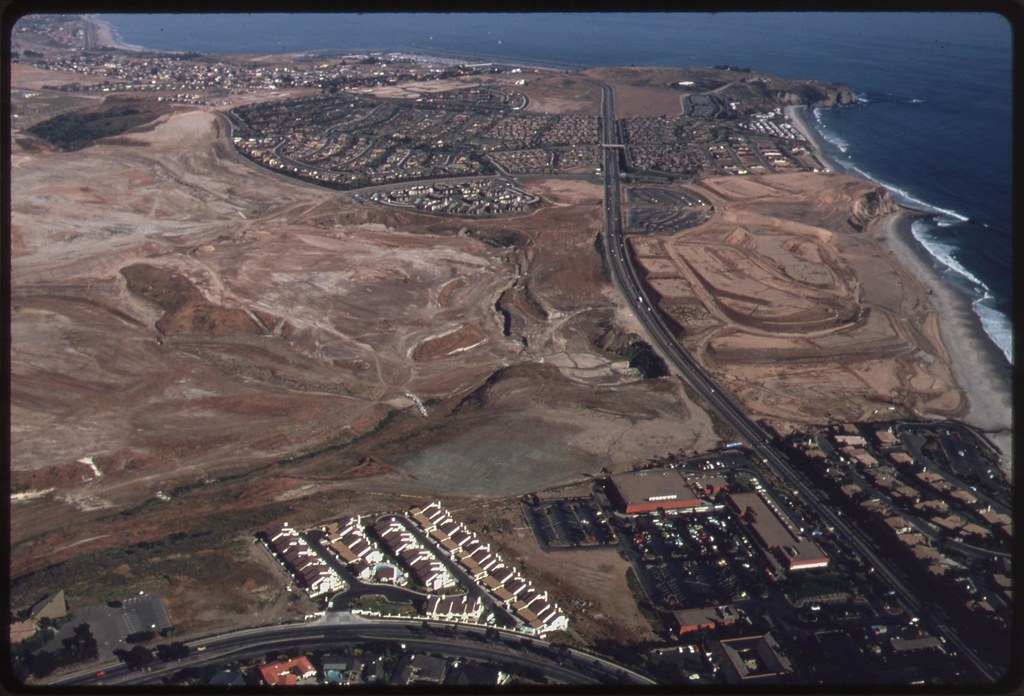
Aerial of land development between Laguna Beach and San Clemente. Work was halted here, and other developments were restricted following state passage in November 1972 of the Coastal Zone Conservation Act: June 1975
Aerial of land development between Laguna Beach and San Clemente. Work was halted here, and other developments were restricted following state passage in November 1972 of the Coastal Zone Conservation Act: June 1975
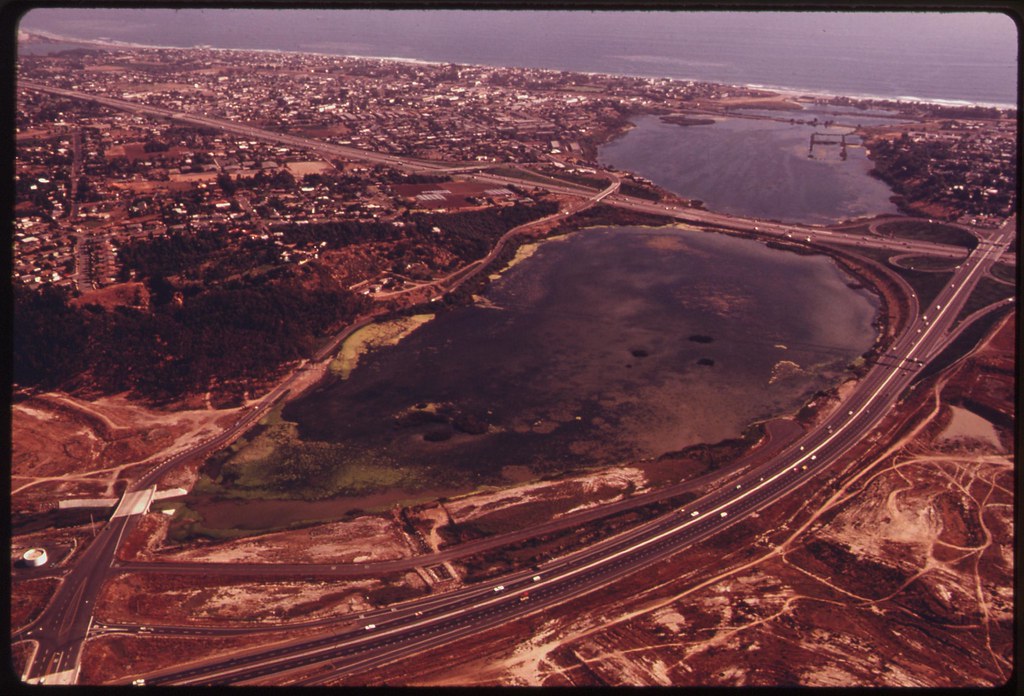
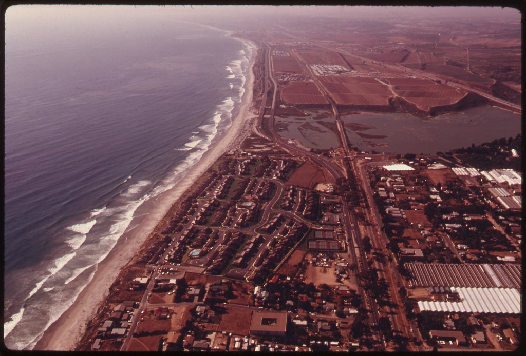
Aerial of Upper Newport Bay in Orange County, south of Los Angeles, showing developed areas. Nearby undeveloped land is scheduled for future heavy development. New construction has been regulated within 1,000 yards of shoreline since 1973. The regulatory commissions must submit a final report to the state legislature in January 1976 recommending passage of laws which will affect the development of the state's coastline: June 1975
Aerial of a marina between Laguna Beach and San Clemente, California. Some 84 percent of the residents of California live within 30 miles of the coast, resulting in land development pressures in that zone. Several planned developments were halted and others restricted after state passage of the Coastal Zone Conservation Act in November 1972. Coastal wetlands decreased from 381,000 acres in 1900 to some 125,000 acres in the early 1970's: June 1975
Aerial of a new housing development in San Diego, California. Some 84 percent of the residents in the state live within 30 miles of the coast which has resulted in mounting land use pressure, particularly along the shoreline. Regulatory commissions were set up in November 1972 to supervise development within 1,000 yards of the coast: June 1975
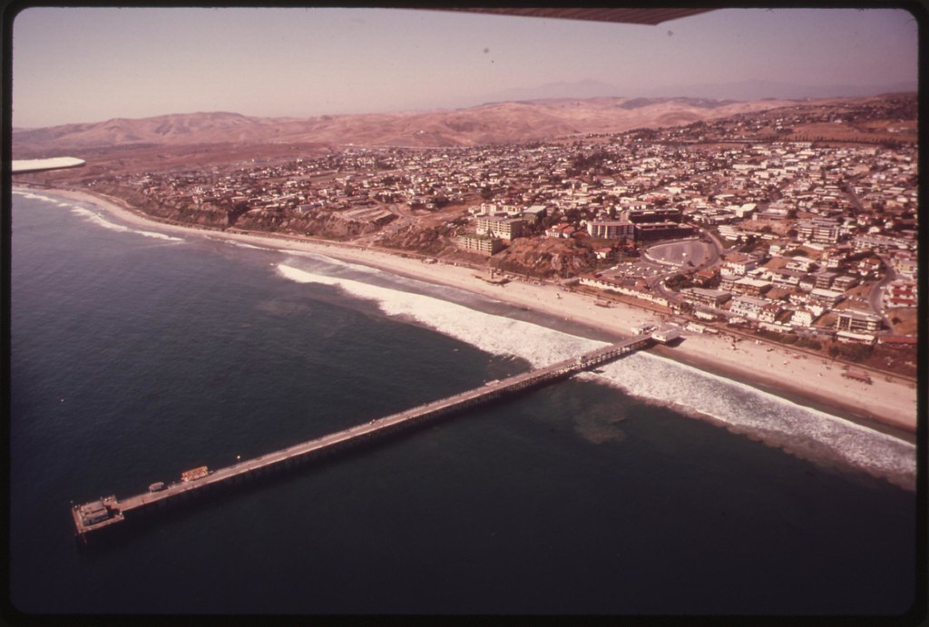
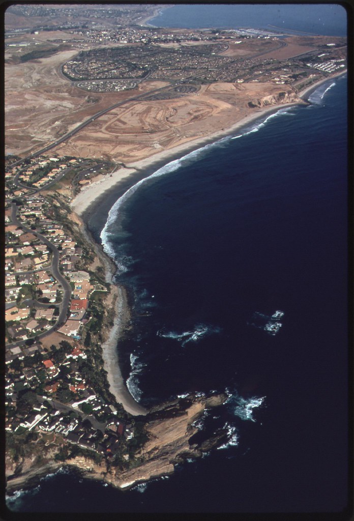
Aerial of Southern California coastline showing San Clemente. Some 84 percent of the residents in the state live within 30 miles of the coast which has resulted in mounting land use pressure. In an effort to regulate future development within 1,000 yards of the shoreline, the state passed a Coastal Zone Conservation Act in November 1972 regulatory commissions must submit a plan to the legislature by January 1976, recommending a "constitution" that will affect future coastal development: June 1975

Construction work on expansion of the San Onofre nuclear generating plant, south of Los Angeles. The sea wall around the construction forces swimmers to detour and swim about 100 yards to reach the other beach area: June 1975
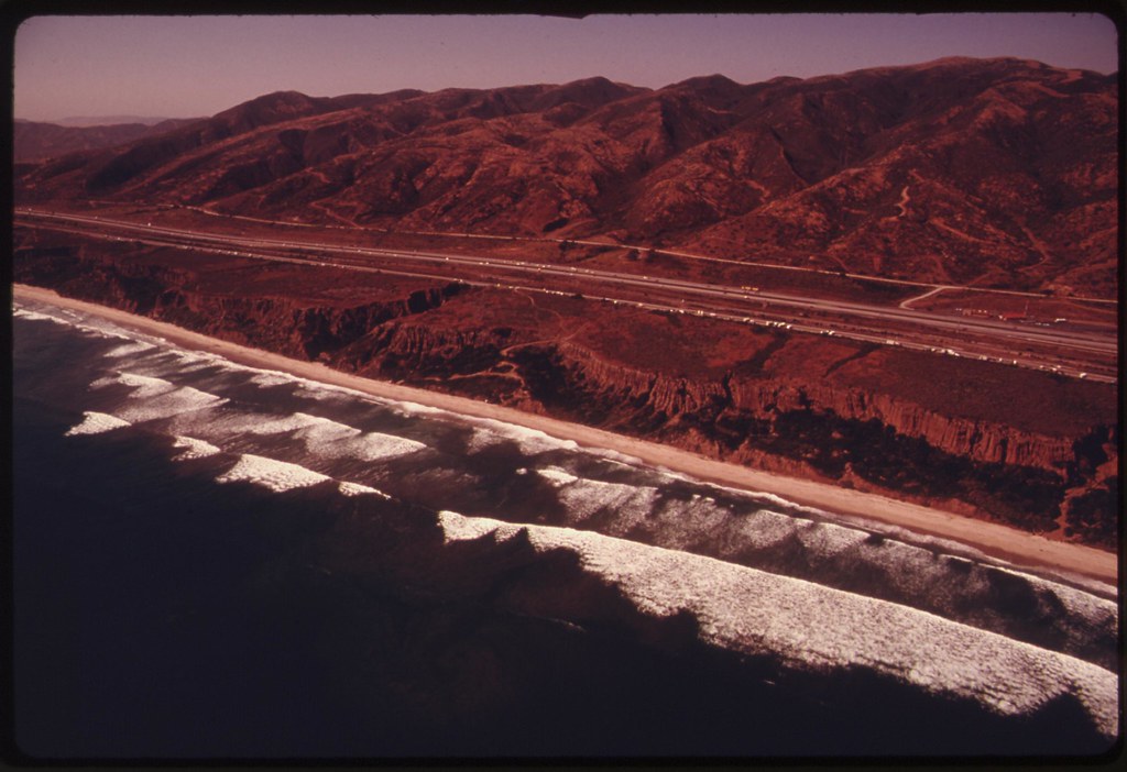
Coastline near San Clemente, California, south of Los Angeles. Some 84 percent of the residents in the state live within 30 miles of the coast which has resulted in mounting land use pressure. Since 1900 the number of coastal wetlands has decreased from 381,000 to about 125,000 acres state and regional commissions have been set up to regulate development within 1,000 yards of the shoreline: June 1975
Employee near the construction site for the expansion of the San Onofre nuclear generating plant, San Clemente, California, warns swimmers to detour to the beach. Located south of Los Angeles, the work area has a sea wall which forces swimmers to detour and swim about 100 yards to reach the other beach area: June 1975
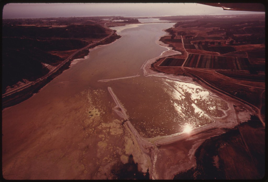
Buena Vista Lagoon, Oceanside, San Diego County, California, suffers from septic tank seepage, erosion and other ills, it is an example of one of the last lagoons in southern California. The body of water is an excellent bird refuge but is becoming surrounded by freeways and developments. Coastal wetlands necessary to maintain wildlife totaled some 381,000 acres in 1900. By the early 1970's that amount had decreased to about 125,000 acres: June 1975

Motorist feeds birds at the Buena Vista Lagoon. The wildlife sanctuary is one of the last lagoons in southern California. There is concern for the body of water because of erosion and septic tank seepage, and the fact that it is being surrounded by freeways and developments. Coastal wetlands necessary to maintain wildlife totaled some 381,000 acres in 1900. By the early 1970's that amount had decreased to about 125,000 acres: June 1975
Dead fish floats in Buena Vista Lagoon, Oceanside, California. The wildlife sanctuary is one of the last lagoons in southern California. There is concern for it because of erosion and septic tank seepage, and the fact that it is being surrounded by freeways and developments: June 1975

Buena Vista Lagoon, Oceanside, California, is one of the last bodies of water of this type in southern California. There is concern for the wildlife sanctuary because of erosion and septic tank seepage, and the fact that it is being surrounded by freeways and developments. Coastal wetlands necessary to maintain wildlife totaled some 381,000 acres in 1900. By the early 1970's that amount had decreased to about 125,000 acres: June 1975
Aerial of Buena Vista Lagoon, Oceanside, California. It is one of the last lagoons in southern California. There is concern the wildlife sanctuary is endangered because of erosion and septic tank seepage, and the fact that it is being surrounded by freeways and developments: June 1975
Botaquito Lagoon, Carlsbad, California, is one of the last few bodies of water of this type in the southern part of the state. It suffers from nearby freeways and developments as well as farm erosion and septic tank seepage: June 1975
Sign advertises homesites in the Santa Monica Mountains off Mulholland Drive on the western edge of Los Angeles. The mountains contain the last semi-wilderness in Los Angeles County: May 1975
Aerial of land development between Laguna Beach and San Clemente. Work was halted here, and other developments were restricted following state passage in November 1972 of the Coastal Zone Conservation Act. Since 1900 coastal wetlands have decreased from 381,000 acres to about 125,000 acres in the early 1970's: June 1975
Aerial of land development between Laguna Beach and San Clemente. Work was halted here, and other developments were restricted following state passage in November 1972 of the Coastal Zone Conservation Act: June 1975
Aerial of land development between Laguna Beach and San Clemente. Work was halted here, and other developments were restricted following state passage in November 1972 of the Coastal Zone Conservation Act: June 1975
Aerial of Upper Newport Bay in Orange County, south of Los Angeles, showing developed areas. Nearby undeveloped land is scheduled for future heavy development. New construction has been regulated within 1,000 yards of shoreline since 1973. The regulatory commissions must submit a final report to the state legislature in January 1976 recommending passage of laws which will affect the development of the state's coastline: June 1975
Aerial of a marina between Laguna Beach and San Clemente, California. Some 84 percent of the residents of California live within 30 miles of the coast, resulting in land development pressures in that zone. Several planned developments were halted and others restricted after state passage of the Coastal Zone Conservation Act in November 1972. Coastal wetlands decreased from 381,000 acres in 1900 to some 125,000 acres in the early 1970's: June 1975
Aerial of a new housing development in San Diego, California. Some 84 percent of the residents in the state live within 30 miles of the coast which has resulted in mounting land use pressure, particularly along the shoreline. Regulatory commissions were set up in November 1972 to supervise development within 1,000 yards of the coast: June 1975
Aerial of Southern California coastline showing San Clemente. Some 84 percent of the residents in the state live within 30 miles of the coast which has resulted in mounting land use pressure. In an effort to regulate future development within 1,000 yards of the shoreline, the state passed a Coastal Zone Conservation Act in November 1972 regulatory commissions must submit a plan to the legislature by January 1976, recommending a "constitution" that will affect future coastal development: June 1975
Construction work on expansion of the San Onofre nuclear generating plant, south of Los Angeles. The sea wall around the construction forces swimmers to detour and swim about 100 yards to reach the other beach area: June 1975
Coastline near San Clemente, California, south of Los Angeles. Some 84 percent of the residents in the state live within 30 miles of the coast which has resulted in mounting land use pressure. Since 1900 the number of coastal wetlands has decreased from 381,000 to about 125,000 acres state and regional commissions have been set up to regulate development within 1,000 yards of the shoreline: June 1975
Employee near the construction site for the expansion of the San Onofre nuclear generating plant, San Clemente, California, warns swimmers to detour to the beach. Located south of Los Angeles, the work area has a sea wall which forces swimmers to detour and swim about 100 yards to reach the other beach area: June 1975
Buena Vista Lagoon, Oceanside, San Diego County, California, suffers from septic tank seepage, erosion and other ills, it is an example of one of the last lagoons in southern California. The body of water is an excellent bird refuge but is becoming surrounded by freeways and developments. Coastal wetlands necessary to maintain wildlife totaled some 381,000 acres in 1900. By the early 1970's that amount had decreased to about 125,000 acres: June 1975
Motorist feeds birds at the Buena Vista Lagoon. The wildlife sanctuary is one of the last lagoons in southern California. There is concern for the body of water because of erosion and septic tank seepage, and the fact that it is being surrounded by freeways and developments. Coastal wetlands necessary to maintain wildlife totaled some 381,000 acres in 1900. By the early 1970's that amount had decreased to about 125,000 acres: June 1975
Dead fish floats in Buena Vista Lagoon, Oceanside, California. The wildlife sanctuary is one of the last lagoons in southern California. There is concern for it because of erosion and septic tank seepage, and the fact that it is being surrounded by freeways and developments: June 1975
Buena Vista Lagoon, Oceanside, California, is one of the last bodies of water of this type in southern California. There is concern for the wildlife sanctuary because of erosion and septic tank seepage, and the fact that it is being surrounded by freeways and developments. Coastal wetlands necessary to maintain wildlife totaled some 381,000 acres in 1900. By the early 1970's that amount had decreased to about 125,000 acres: June 1975
Aerial of Buena Vista Lagoon, Oceanside, California. It is one of the last lagoons in southern California. There is concern the wildlife sanctuary is endangered because of erosion and septic tank seepage, and the fact that it is being surrounded by freeways and developments: June 1975
Botaquito Lagoon, Carlsbad, California, is one of the last few bodies of water of this type in the southern part of the state. It suffers from nearby freeways and developments as well as farm erosion and septic tank seepage: June 1975
Aerial of Botaquito Lagoon, Carlsbad, California, one of the last few bodies of water of this type in the southern part of the state. It suffers from nearby freeways and developments as well as farm erosion and septic tank seepage: June 1975
Aerial of Botaquito Lagoon, Carlsbad, California, one of the last few bodies of water of this type in the southern part of the state. It suffers from nearby freeways and developments as well as farm erosion and septic tank seepage: June 1975
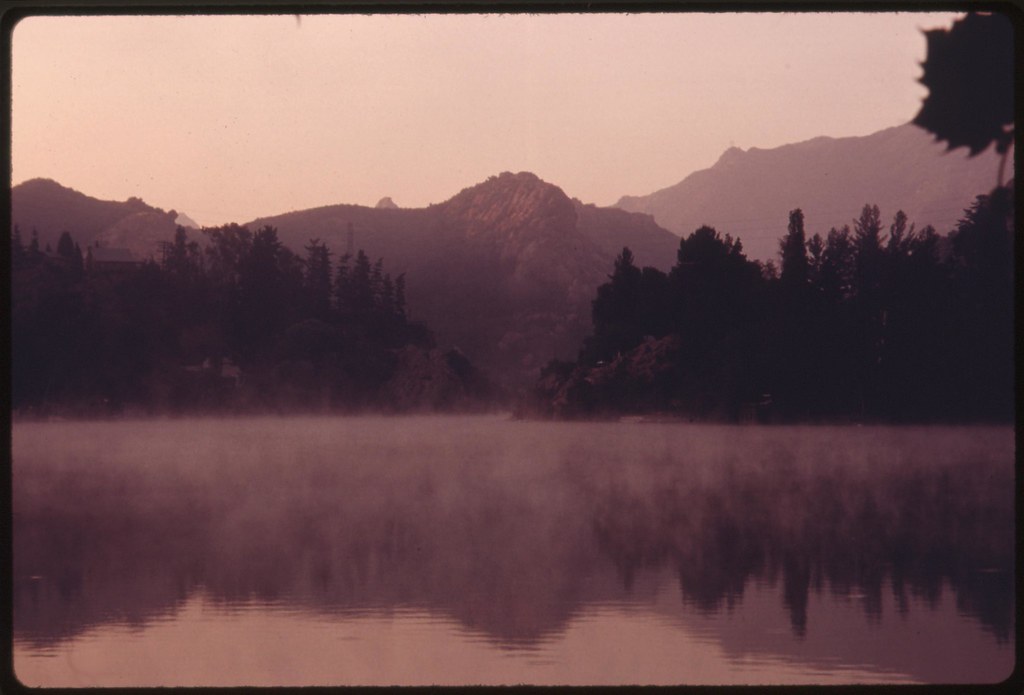
Early morning at Malibu Lake in the Santa Monica Mountains near Malibu, California, which is located on the northwestern edge of Los Angeles County. The mountains contain the last semi-wilderness in Los Angeles County: May 1975
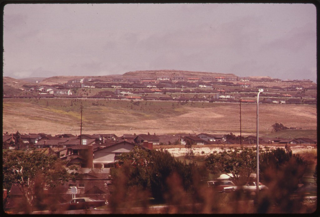
Morning fog clearing over Oxnard Plain, a prime agricultural area now being developed for housing near Oxnard California, north of Los Angeles: June 1975
Photos by Charles O'Rear (1941-) from the DOCUMERICA series, an Environmental Protection Agency program to photographically document subjects of environmental concern, compiled
1972-1977 (U.S. National Archives)


7 comments:
A fine dirge this morning, Tom, as we watch this sad parade tootle and thump its way into the sunset, resolutely unaware that over the horizon, beyond the well-developed foreground, the earth drops away to nothing. That anybody’s ever owned any of this is an illusion, and a convenient lie.
Hazen,
The lie wrapped inside the advertisement rolled up around the illusion was always going to be the lay of that land once the Spanish left it behind.
We spent the early 80s down there. The cancer-causing chemicals issuing from outflow pipes into the waters of the surfing beaches did get a bit of notice in the LA Times.
"...the earth drops away to nothing" puts me in mind of the best prose I've ever read on the place, a work made with the special objectivity of the eyes of a stranger.
This from Gavin Lambert: The Slide Area (1959):
It is only a few miles’ drive to the ocean, but before reaching it I shall be nowhere. Hard to describe the impression of unreality, because it is intangible; almost supernatural; something in the air. (The air . . . Last night on the weather telecast the commentator, mentioning electrical storms near Palm Springs and heavy smog in Los Angeles, described the behavior of the air as ‘neurotic’. Of course. Like everything else the air must be imported and displaced, like the water driven along huge aqueducts from distant reservoirs, like the palm trees tilting above the mortuary signs and laundromats along Sunset Boulevard.) Nothing belongs. Nothing belongs except the desert and the gruff eroded-looking mountains to the north. Because the earth is desert, its surface always has that terrible dusty brilliance. Sometimes it looks like the Riviera with a film of neglect over villas and gardens, a veil of fine invisible sand drawn across tropical colours. It is hard to be reminded of any single thing for long. These houses are real because they exist and people use them for eating and sleeping and making love, but they have no style of their own and look as if they've been imported from half a dozen different countries. They are imitation 'French Provincial' or 'new' Regency or Tudor or Spanish hacienda or Cape Cod, and except for a few crazy mansions seem to have sprung up overnight. The first settlers will be arriving tomorrow from parts unknown.
[contihues:]
How to grasp something unfinished yet always remodeling itself, changing without a basis for change? So much visible impatience to be born, to grow, such wild tracts of space to be filled: difficult to settle in a comfortable unfinished desert. Because of the long confusing distances, the streets are empty of walking people, full of moving cars. Between where you are and where you are going to be is a no-man's-land. At night the neon signs glitter and the shop windows are lighted stages, but hardly anyone stops to look. A few people huddle at coffee stalls and hamburger bars. Those dark flat areas are parking lots, crammed solid.
I suppose that Europeans, accustomed to a world that changes more calmly and more slowly, are not much interested any more in imitating its surface. It becomes more exciting to see appearances as a mask, a disguise or illusion that conceals an unexpected meaning. The theme of illusion and reality is very common in Europe. In America, illusion and reality are still often the same thing. The dream is the achievement, the achievement is the dream.
.
The ocean appears suddenly. You turn another hairpin bend and the land falls away and there is a long high view down Santa Monica Canyon to the pale Pacific waters. A clear day is not often. Sky and air are hazed now, diffusing the sun and dredging the ocean of its rightful blue. The Pacific is a sad blue-grey, and nearly always looks cold.
Each time I drive down here it feels like the end of the world. The geographical end. Shabby and uncared for, buildings lie around like nomads' tents in the desert. There is nowhere further to go, those pale waters stretch away to the blurred horizon and stretch away beyond it. There is no more land ever.
High lurching cliffs confront the ocean, and are just beginning to fall apart. Signs have been posted along the highway, DRIVE CAREFULLY and SLIDE AREA. Lumps of earth and stone fall down. The land is restless here, restless and sliding. Driving inland towards the mountains, it is the same: BEWARE OF ROCKS. The land is falling. Rocks fall down all over and the cliffs called Pacific Palisades are crumbling slowly down to the ocean. Who called them Palisades, I wonder? They cannot keep out the Pacific. There are mad eccentric houses above the Palisades, with turrets and castellations and tall Gothic windows, but no one wants to live in them any more in case the ground slides away.
Nice to see my photos after near 40 years. this is the first effort I've seen to describe in photos the California coast problems.
Charles O'Rear
St. Helena, California
www.wineviews.com
Make sure you look good in every scene
Never mind Eros and Thanatos - this would seem to be the fundamental drive these days.
It's incredible to read the Lambert piece and realise it was written over fifty years ago.
The pictures are distressing; they eat at the conscience.
Lambert is splendid in capturing a place of heart-breaking beauty and wild nature as it succumbs to the mindless human wave. The mania for “growth”—at base a neurosis, mere appetite without restriction or limit—has been part of our damaged psyche ever since civilization first twisted its roots into the earth. Our history is one of speculation in everything, whether tangible or intangible, for the sole purpose of material gain. Long term or short, what possible good could come of a race whose main impetus for living is to make money?
The portfolio seems to capture history poised at a decisive moment of change. As we've learned since then, there was never going to be any going back -- only onward over the edge.
Chuck, we're all very grateful to you for this great work. The pretty person in the household stuck out hard for including as many of the aerials as could be managed. The post was already groaning with the load by then, so regrettably I had to part with a dozen or more lovely shots of the wetlands plant and animal life endangered (ultimately to be doomed) by the advancing development.
The elegiac feeling in the photos however remains very strong, that sense of all that was lost, in return for ... what was it again?
I think Hazen catches this quality in his words about the mindless wave overcoming the heartbreaking beauty -- both of these aspects revealed at once in many of the shots in this invaluable survey.
So this is when the wave was coming on, and now it's long since won the day. Though perhaps there is still a happy valley hidden away somewhere down the road apiece on Ecology Drive.
Unless it's been renamed Oblivion Drive, that is.
As WB puts it so well -- "Never mind Eros and Thanatos - this would seem to be the fundamental drive these days."
Post a Comment