.

Map of Oklahoma and Indian territories, 1905 (Library of Congress Geography and Map Division)
Map of the Indian and Oklahoma territories, 1892 (Library of Congress Geography and Map Division)
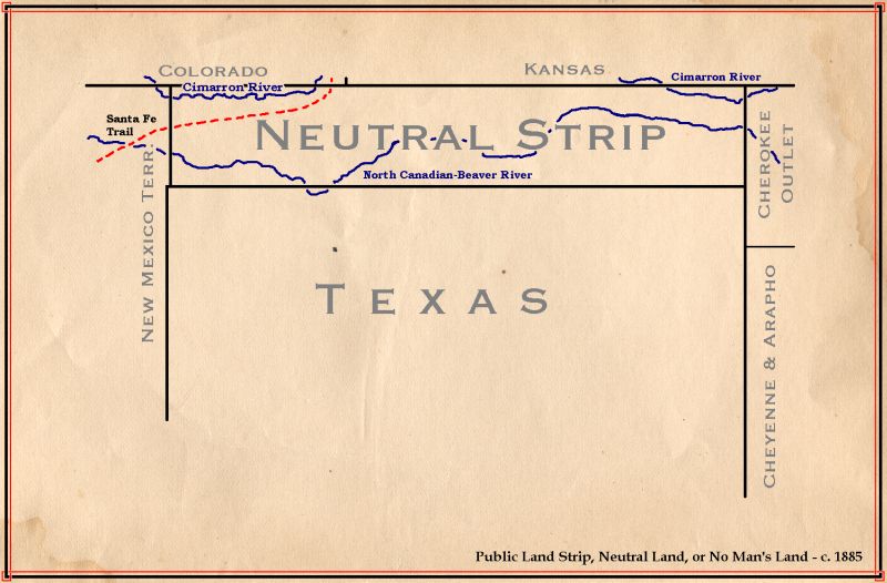
Map of No Man's Land, Oklahoma, c. 1885: author unknown (image by CPret, 2004)

Map of Oklahoma and Indian Territory, c. 1890s: image by Kmusser, 2010


Oklahoma Land Rush, 22 April 1889, from McClenny family album, with John Sherwood seen on the white horse, Elias McClenny ahead of him, Fred McClenny just behind him: photographer unknown (National Archives and Records Administration; image by Chris 73, 2010)

Oklahoma City post office, 22 April, 1889: artist unknown, from Harper's Weekly, Saturday 23 April, 1892 (image by Infrogmation, 2008)

Oklahoma City Today -- Main Broadway (view of Oklahoma City, early 1892): artist unknown, from Harper's Weekly, Saturday, 23 April 1892 (image by Infrogmation, 2008)

Guthrie, Oklahoma viewed on April 24, 1889; May 10, 1889; and May 10 1893 during Governor's visit; showing rapid development of the city after land run following "opening" of former Indian lands: photos from E. Benjamin Andrews. History of the United States, Volume V, 1912 (image by SEWilco, 2007)
Willie-Cries-for-War oil well at Miller Bros. 101 Ranch, Oklahoma: photographer unknown, c. 1911 (image by Jmcapital, 2007)

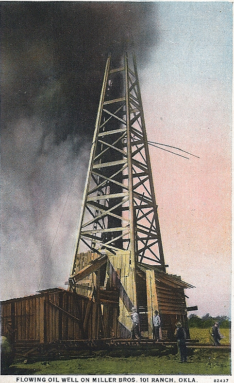
Gusher, Miller Bros. 101 Ranch, Okemah, Oklahoma, 1922: photo from National Archives and Records Administration (image by PlainEarth, 2007)

Trails of Tears: map of Indian Removals courtesy of Demis from Wilcomb E. Washburn, Handbook of North American Indians, Vol. IV: History of Indian-White Relations, 1988 (image by Nikater, 2007)

Barefoot corpse of Laura Nelson, lynched May 25, 1911, Okemah, Oklahoma. (District Judge Caruthers convened a grand jury in June 1911 to investigate the lynching of Laura Nelson and her son. In his instructions to the jury, he said, "The people of the state have said by recently adopted constitutional provision that the race to which the unfortunate victims belonged should in large measure be divorced from participation in our political contests, because of their known racial inferiority and their dependent credulity, which very characteristic made them the mere tool of the designing and cunning. It is well known that I heartily concur in this constitutional provision of the people's will. The more then does the duty devolve upon us of a superior race and of greater intelligence to protect this weaker race from unjustifiable and lawless attacks"): postcard photo by G.H. Farnum, 1911 (image by Jarekt, 2008)

Birthplace of Woody Guthrie, Okemah vicinity, Okfuskee, Oklahoma; exterior, general view: photo by Walter Smalling, after 1933 (Historic American Buildings Survey, Library of Congress)

Oklahoma Farmers Parade in downtown Coweta, Oklahoma, 1905: photographer unknown (Mission Bell Museum, Coweta, Oklahoma)
Fourth of July, Woodward, Oklahoma, 1912: photo by McDonald Studio, Woodward, Oklahoma (image by Popsiclecrawfish, 2006)

Bird's-eye view of business section, Muskogee, Oklahoma: photographer unknown, from postcard published by the Paul C. Koeber Company, New York, c. 1910 (image by Hugh Manatee, 2009)


7 comments:
This rises and rises, then falls to great depths and sort of planes out. Words are both insufficient and unnecessary. The Indian Removal map is something I’ve never seen before. It’s horrible, but I recognize that it’s contemporary and part of a history book. The old maps are extremely beautiful, as they always are.
You observed the other day that “blogs are meant to be a place for the momentary, not for history. But some things do deserve remembering all the same.”
I definitely feel this on the pulses.
Thanks very much, Curtis.
Putting together this series has been a bit harrowing, in terms both of the labour involved, and perhaps more deeply, of the lessons learned along the way about our buried histories.
In a curious fashion that emerged in the course of the research, the story of Oklahoma came to appear a parabolic tale of American enterprise, ruthlessness and greed, writ on a vast canvas that might easily be considered empty... if one overlooks the fact that there were, before the land runs of 1889-1893, Indians living on it.
Anyway, I'm encouraged by your saying that you can feel it. There was no other reason for it to happen, really.
Tom,
Yes, as Curtis says, here too -- "feel it on the pulses." Views of "the American enterprise" continued too, on drive down 25 from Fort Collins to Denver, miles and miles of recently built houses (with attendant traffic) where, someone said, there was nothing there but fields 20 years ago. . . .
1.15
orange of sky on horizon above blackness
of trees, silver of planet beside leaves
in foreground, sound of waves in channel
lights still on tree, white
reflections in window
frogs sounding, Orion still,
white of gibbous moon
pattern of branches in bright blue sky,
shadowed green of ridge across from it
Choctaw country still wild/McCurtain county
Broken Bow has a casino
end point of The Trail of Tears
(the southern branch)
Steve, that Denver to Fort Collins strip was already tractifying in a pretty ugly way during my years in those parts (more than three decades ago now, a mere moment in Developer-Time). The then already extending eastern flats of Boulder did certainly seem saddening in a special American way, representing that great homogenized latterday whiteworld sameness. But at least back then in the late Seventies there were still some empty stretches above and below Longmont, as I recall. Now Berthoud, there was a town I kind of liked (a stop on epic bike adventures, ah yesteryear), with actual mature shade trees on streets of large if plain houses with screened-in front porches, à la the America of another century, & c. So what's the deal now, one long tract strip all the way?
And thank you, Elmo, again, for covering your general region for us. A discerning eye on the landscape of the present that also recalls the histories buried below, oh how rare, how precious. There is nothing more beautiful than local knowledge.
And yes, I have now corroborated that down there at the end of the Trail of Tears, The Choctaw Casino in Broken Bow boasts 461 slots, and on Friday and Saturday nights the gaming goes on until 5 in the morning.
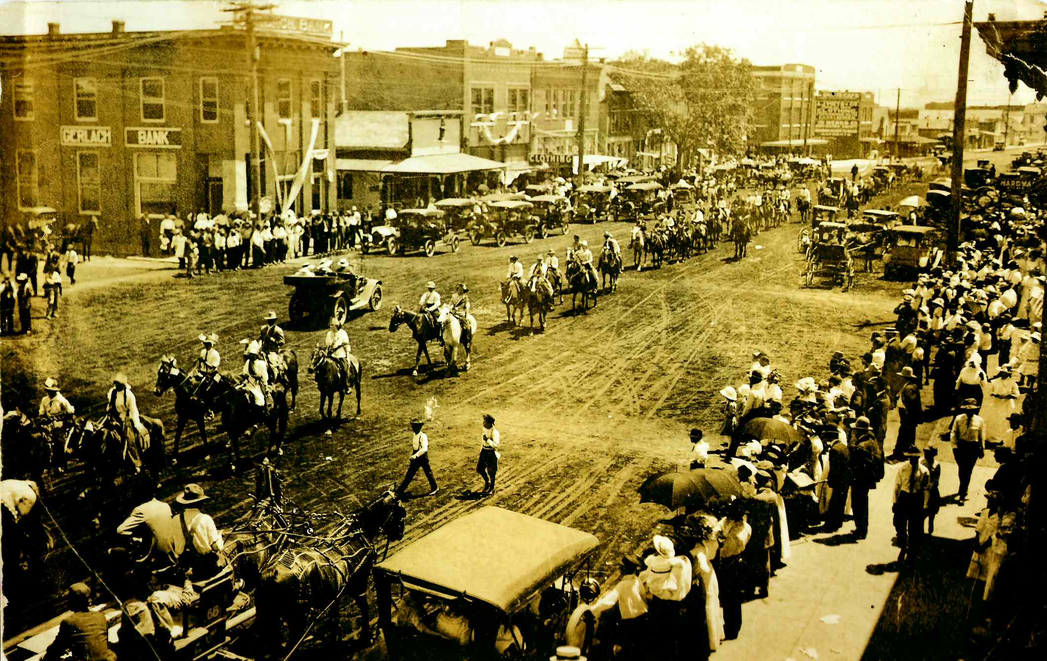
And speaking of useful local knowledge, Ron Padgett, our trusty Oklahoma correspondent, reports particular interest in that early photo of the Farmers' Parade in Downtown Coweta, Oklahoma, 1905, due to "personal associations": "I'm pretty sure that my maternal grandparents lived on a farm outside of Coweta about 10 years after this photo was taken." And one of Ron's wife's sisters, as he also says, lived in Broken Arrow, the town whose main street is pictured in the fourth photo here.
Further, on the subject of the land runs (which lies at the heart of this whole series of posts), RP refers us to his memoir of his father: "... take a peek at the appendix dealing with law and order in Oklahoma. The land grab started well before the Land Rush. The US Congress saw to that. But there were some white men who moved into Indian Territory years before the Rush and intermarried with the Indians, started farms, little businesses, and raised families, on a modest scale, of course."
You can visit Ron's website to read an excerpt from Oklahoma Tough: My Father, King of the Tulsa Bootleggers (U. of Oklahoma Press). It is a vivid account of interesting ways and times, now long gone.
(Without opening up some passageways to the present, any consideration, from this distance in time and space, of the history of the land and the peoples upon it -- the great everything that is always a part of the great everything else -- must inevitably remain pretty academic. But thankfully we now have had some contemporary perspectives from informed friends; to whom whom I am indebted.)
Ce travail de mémoire qu'est le votre est autant remarquable que saisissant... Once more,your posts dedicated to the genuine memory of History, are as remarkable as moving.
Je vous remercie, caaya. La véritable mémoire de l'histoire est peut-être comme une rivière qui coule autour de chacun, dans nos îles privées ... et la rivière est toujours supérieure à ses îles.
Post a Comment